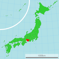
Aichi Prefectur
Appearance
Aichi Prefecture 愛知県 | |
|---|---|
| Japanese transcription(s) | |
| • Japanese | 愛知県 |
| • Rōmaji | Aichi-ken |
 | |
| Coordinates: 35°10′48.68″N 136°54′48.63″E / 35.1801889°N 136.9135083°ECoordinates: 35°10′48.68″N 136°54′48.63″E / 35.1801889°N 136.9135083°E | |
| Kintra | Japan |
| Region | Chūbu |
| Island | Honshu |
| Caipital | Nagoya |
| Govrenment | |
| • Govrenor | Hideaki Ōmura (since February 2011) |
| Area | |
| • Total | 5,153.81 km2 (1,989.90 sq mi) |
| Area rank | 28t |
| Population (1 Februar 2011) | |
| • Total | 7,408,640 |
| • Rank | 4t |
| • Density | 1437.51/km2 (3,723.1/sq mi) |
| ISO 3166 code | JP-23 |
| Destricts | 7 |
| Municipalities | 54 |
| Flouer | Kakitsubata (Iris laevigata) |
| Tree | Hananoki (Acer pycnanthum) |
| Bird | Scops-owl (Otus scops japonicus) |
| Fish | Kuruma prawn (Penaeus japonicus) |
| Website | pref.aichi.jp/global/en |
Aichi Prefectur (愛知県 Aichi-ken) is a prefectur o Japan locatit in the Chūbu region.[1] The region o Aichi is kent as the Tōkai region. The caipital is Nagoya. It is the focus o the Chūkyō Metropolitan Aurie.[2]
| This Japan-relatit airticle is a stub. Ye can help Wikipaedia bi expandin it. |
Notes
[eedit | eedit soorce]- ↑ Nussbaum, Louis-Frédéric. (2005). "Aichi-ken" Japan Encyclopedia, p. 11 at Google Books; "Chūbu" Japan Encyclopedia, p. 126 at Google Books.
- ↑ Nussbaum, "Nagoya" p. 685 at Google Books.
Freemit Airtins
[eedit | eedit soorce]| Wikimedia Commons haes media relatit tae Aichi Prefectur. |
 Travel guide tae Aichi Prefectur frae Wikivoyage
- Offeecial Aichi Prefectur hamepage
- Aichi Prefectural Tourist Association Archived 2014-02-20 at the Wayback Machine


