
Sorbie

Sorbie is a smaw veelage in the Machars in the historical coonty o Wigtounshire in Dumfries an Gallowa, Scotland.[1][2]
It is locatit midwey atween Wigtoun an Whithorn on the A714 road.
Fermin forms the principal local industry in the aurie.
The Sorbie Veelage Haw is uised bi a nummer o groups.[3]
Sorbie Pairish Kirk, in the centre o the veelage, dates fae aroond 1755 an is a lairge T-plan structur, noo de-ruift.
Millisle Kirk, 0.6 mile wast o Garlieston, wis designt bi Alan Stewart, 10t Yerl o Gallowa.
An infaw on the Wigtownshire Railway appent in Millisle in 1876. Sorbie railwey station on the Wigtownshire Railway brainch o the Portpatrick and Wigtownshire Joint Railway that closed in 1964 umwhile served Sorbie veelage.
For mony years Sorbie hid a creamery locatit aside the railwey station, some o whase products wis aince exportit via the port at nearby Garlieston. The creamery closed feenal in the 1990s an the site is noo occuppee'd bi a granite warks. Galloway Granite his noo flittit tae Newtoun Stewart an the warks noo appear tae be abandont an in a state o ruination.
History
[eedit | eedit soorce]Sorbie pairish wis a 17t century amalgamation o Sorbie, Kirkmadrine, an Cruggleton. Timothy Ponts 17t century map shaws Kirck o Cruggletown.[4][5]
Ainslie's 1782 map shaws Sorby Parish an the kirk by the Veelage o Sorbie.[6]
In 1846 the pairish wis an aurie aboot 6 mile lang and atween 3.5 mile til awmost 6 mile wide, composed o 9,000 acre, o that 7,700 acre is arable wi a moderate skarin o pasturs an meidaes, 400 acre is wuidland an plantations, an the lave is muirland.[7]
Cruggleton Castle that wis abandont in the 17t century is a wheen o miles sooth o Garlieston.[8]
Sorbie Tour, ae mile east o Sorbie, wis the seat o the Clan Hannay.
Thare is an early medieval motte near Sorbie Tour.[9]
The auld places o Broughton Skeog an Broughton Mill is shawn juist wast o Gallowa Hoose, Sorbie, in John Ainslie's 1782 map.[10]
Gallowa Hoose, the seat o the Yerl o Gallowa, is a stately big hoose biggit aboot the mid o the 18t century, an situatit on the nearby coast atween Garliestoun Bay an Rigg Bay.[7] Locatit within Gallowa Hoose Gairdens is the runs o a wheen o cots. The cots merk the site o Carswell veelage that wis situatit in Rigg Bay. Whan the Yerl o Gallowa decidit he wantit tae built a grand new hoose cried Gallowa Hoose nearby, he muived the people fae Carswell.
On Ainslie's 1782 map[11] Dowalton Loch (Langcastle) is shawn tae be in the pairish o Sorbie.
In wast Sorbie is the site o Dowalton Loch, cried an aw Ravenston an Langcastle. The loch wis aboot 3 mile aroond an fae sax tae twinty fit deep that, whan soukit, wis fund tae conteen twa smaw islands o crannogs o the prehistoric woners. Five canoes wis fund in the loch. On the islands, an in thair neebourheid, wis diskivert an aw several veshels o bronze, beads o gless, vitreous glouter, lammer, queerns, whatstanes, etc. (ref. Dr Stuart's address til the Archeological Society of Glasgow, 1865-6).[12]
Doon Hill fort o sattlement is juist ablo the heichest pynt o Doon Hill, on a sclent facin the soothwast, conseestin o twa yirden rampairts wi a medial ditch, meisurin aboot 144 fit east-tae-wast bi abbot 111.5 fit thort fae centre tae centre o the inby rampairt. An ingang micht hae been in the nor'wast side. The bind an form o the yirdwark, thegither wi its situation on teh sclentin grund, place it in a cless common in Wigtounshire.[13][14]
Eggerness Airn-Age Promontory Fort is in Sorbie.[15]
-
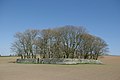
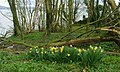
 Sorbie Veelage, Wigtounshire.
 -
 Galloway Granite Warks, umwhile a creamery, north o Sorbie.
 -
 Cruggleton Chaipel. 1875. bi Peter Handyside MacKerlie
 -
 sortit 12t century Cruggleton Kirk efterwart Sorbie Kirk.
 -
 sortit Cruggleton Kirk efterwart Sorbie Kirk.
 -
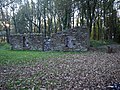
 Sorbie, Auld Pairish Kirk ruin.
 -
 Sorbie, sortit kirk.
 -
 Sorbie Pairish Kirk.
 -
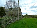
 Carswell Veelage.
 -
 Site o Dowalton (Longcastle) Loch.
 -
 Dwallin site in Sorbie, Dowalton Loch.
 -
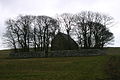
 Motte at Sorbie Tour.
 -
 Eggerness Castle.
 -
 Innerwell Port.


Leetit biggins in Sorbie
[eedit | eedit soorce]- Garlieston, 20 And 21 South Crescent
- Garlieston, 23 South Crescent
- Garlieston,11 South Street
- Garlieston, 13 South Street And Cowgate
- Kirkmadrine, Church And Burial Ground
- Millisle, Sorbie Parish Church (Church Of Scotland) And Churchyard
- Sorbie, 2 Wigtown Road, The Pheasant Inn
- Garlieston, 10 North Crescent
- Garlieston,1 High Street The Queens Hotel And Outbuilding
- Garlieston, Home Farm
- Garlieston, 9 And 10 South Crescent
- Garlieston, 5 South Street Kildarroch House
- Garlieston, 7 South Street
- Garlieston, 25 South Street
- Galloway House And Park Walls
- Galloway House, High Lodge
- Galloway House, Walled Garden Including Gardener's Cottage And Garlieston House
- Garlieston, 11 And 12 South Crescent
- Garlieston, 14 North Crescent
- Garlieston, 6 Cowgate
- Garlieston,6 South Crescent Lynwood
- Garlieston, 15 And 16 South Crescent
- Garlieston, 21 South Street
- Old Place Of Sorbie Also Known As Sorbie Tower
- Sorbie Old Parish Church And Churchyard
- Garlieston, 2 South Crescent
- Galloway House, Wigtown Lodge
- Garlieston, Harbour And Warehouses
- Garlieston 7 North Crescent
- Galloway House, Cruggleton Lodge, Policy Walls And Gates
- Garlieston, 17 South Crescent
- Garlieston,9 South Street Dunroamin
- Sorbie, 5 St John's, St John's Croft
- Garlieston, 15 North Crescent
- Garlieston, 15 Culderry Row Lincoln Cottage
- Garlieston, High Street Mirfield
- Cruggleton Church And Walled Burial Ground
- Galloway House, Garlieston Lodge
- Garlieston, 18 And 19 South Crescent The Harbour Inn
- Garlieston, 22 South Crescent
- Old Manse Of Sorbie
- Sorbie Former Uf Church
- Garlieston, 16 North Crescent
- Garlieston, 17 North Crescent
- Garlieston, 8 North Crescent
- Garlieston, 5 South Crescent
- Garlieston, 3 South Street Oakmere
- Garlieston, 19 South Street Southview
- Pouton Mains
- Garlieston, 4 South Crescent
- Garlieston, 13 South Crescent
- Garlieston, 14 South Crescent
- Garlieston, 2 South Street Garden Walls And Outbuilding To Rear
- Garlieston, North Crescent Garlieston Mill Bridge
- Garlieston 1 South Crescent Torwood
- Cults Farmhouse
- Galloway House, Park Cottage
- Galloway House, Whithorn Lodge
References
[eedit | eedit soorce]- ↑ "Parish of Sorbie from The Gazetteer for Scotland". www.scottish-places.info.
- ↑ http://www.scotlandsplaces.gov.uk/search/?action=do_search&p_type=PARISH&p_name=sorbie&id=1246&p_county=wigtownshire[deid airtin]
- ↑ "Archived copy". Archived frae the original on 24 December 2012. Retrieved 17 October 2012.CS1 maint: archived copy as title (link)
- ↑ "View: Gallovidiae, Pars Occidentalior, in qua Vicecomitatus Victoniensis cum Regalitat... - Blaeu Atlas of Scotland, 1654". maps.nls.uk.
- ↑ "Archived copy". Archived frae the original on 3 Mairch 2016. Retrieved 4 Apryle 2020.CS1 maint: archived copy as title (link)
- ↑ "View: A map of the county of Wigton. - Counties of Scotland, 1580-1928". maps.nls.uk.
- ↑ a b A Topographical Dictionary of Scotland, Samuel Lewis, 1846
- ↑ "Garlieston from The Gazetteer for Scotland". www.scottish-places.info.
- ↑ Historic Environment Scotland. "Monument No. 63151". Canmore. Retrieved 11 December 2012.
- ↑ John Ainslie's AD1782 map http://maps.nls.uk/counties/view/?id=685#id=685&zoom=5&lat=4302.96117&lon=11808.44175&layers=BT
- ↑ "View: A map of the county of Wigton. - Counties of Scotland, 1580-1928". maps.nls.uk.
- ↑ Rambles in Galloway by Malcolm M’Lachlan Harper. pub. 1876 https://archive.org/stream/ramblesingallow00harpgoog#page/n292/mode/2up
- ↑ Historic Environment Scotland. "Monument No. 63239". Canmore. Retrieved 6 December 2012.
- ↑ "Doon Hill". The Megalithic Portal.
- ↑ Historic Environment Scotland. "Monument No. 63187". Canmore. Retrieved 5 December 2012.
| Wikimedia Commons haes media relatit tae Sorbie. |
| This Places o Scotland airticle is a stub. Ye can help Wikipaedia bi expandin it. |