
Portpaitrick
Portpatrick
| |
|---|---|
 | |
 Portpatrick Location within Dumfries an Gallowa | |
| Population | 960 (2001) |
| OS grid reference | NW995545 |
| Ceevil pairish |
|
| Cooncil area | |
| Lieutenancy area | |
| Kintra | Scotland |
| Sovereign state | Unitit Kinrick |
| Post toun | Stranraer |
| Postcode destrict | DG9 |
| Diallin code | 01776 |
| Police | Scots |
| Fire | Scots |
| Ambulance | Scots |
| EU Pairlament | Scotland |
| UK Pairlament | |
| Scots Pairlament | |
Portpaitrick (Scots Gaelic: Port Phàdraig), is a veelage an ceevil pairish in the historical coonty o Wigtounshire in Dumfries an Gallowa, soothwast Scotland. It is locatit on the wast coast o the Rhins o Gallowa. The pairish is aboot 4.5 mile in lenth an 4 mile in brenth, kiverin 9,300 acre.[1][2]
History
[eedit | eedit soorce]Datin back some 700 year an built aside the nearby ruins o Dunskey Castle, Portpatrick's position on the Rhins o Gallowa gies veesitors views o the coast o Northren Ireland 21 mile til the wast, wi clift-tap walks an strands baith north an sooth. The Gulf Stream, flowin in fae the north, gies the coast here a pleisant climate that subtropical plants can floorish in.
Portpaitrick his a Community Cooncil,[3] an a annual Life Boat Week, featurin parauds, actieevitys, an a firewirks shaw.[4] The're bouls clubs, a gowf club, mony guesthooses an hottles, an hameower taverns. The veelage is hame an aw til a mini puttin coorse.
Aside the inner herbour is the stairtin pynt o the Soothren Upland Wey, a lang-range walkin route tae Cockburnspaith on the east coast. The Portpatrick Hotel, built in 1905 an extendit in 1907, sits on the clifts abuin this pynt.
The veelage wis uised as yin o the locations for the 1952 pictur Hunted starnin Dirk Bogarde an directit bi Charles Crichton. It featurt an aw in the BBC drama Two Thousands Acres of Sky as a substitute for Portree.
Featurs
[eedit | eedit soorce]Herbour
[eedit | eedit soorce]
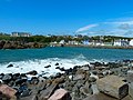
Portpaitrick veelage wis foondit on fishin, operatin fae the saundy, crescent-shapen herbour that remeens the focal pynt o the veelage nouadays. Attempts wis made tae mak it safer fae the strang Sheuch (North Chainel) gells. In 1770 John Smeaton, the leadin ceevil ingineer o his day, wis appyntit tae mak forder impruivements. He biggit fleet-dykes that chainged the saundy bay intil a hained herbour. Strang wastlin winds an waws hinderly brak throu this wirks, an in 1821 John Rennie the Younger wis appyntit tae creaut a new herbour define't bi twa new piers. Siller problems an wather problems meant that thir piers wis niver feenisht. The caum inner basin, noo hame til the port's lifeboat, wis biggit atween 1861 an 1863, ower late tae kep the government muivin the mail service tae boats that sailt atween Stranrawer an Lairne. The herbour reteens a fleet o fishin boats, a NAVTEX, an a lifeboat station.
St Paitrick's Kirk
[eedit | eedit soorce]
This ruint kirk, datin fae 1629, micht itsel staund on the ruins o an earlier kirk, kent as St Paitrick's Chaipel. The circular tour micht date fae the 1520s, an stuid oreeginal on its lane. Its unuisual shape (for Scotland) micht mean that it wis aither a lichthoose for the herbour, or influence't hivily bi Erse airchitectur.
In the 18t an 19t centurys, whan Portpaitrick wis an important ferry port for passengers, postal mail, an fraucht atween Ireland an Scotland, the veelage wis descrived as "the Gretna Green for Scotland".The war a daily packet boat fae Donaghadee, and mairiages for couples fae Ireland wis conductit bi the Kirk o Scotland meenister in Portpaitrick, awtho accordin tae Brack (1997) he aften mislippent the rules aboot the publication o cries or the require't speal o residence. It is believed that happy couples coud disembark, complete the ceremony, an be back on the boat within ae oor.
The haly-muild aroond the kirk conteens memorials tae mony veectims o shipwracks in nearby watters. Jyned til the oreeginal chaipel wis a destrict bi the name o the Black Quarter o Inch. Whan the kirk wis rebuilt in 1629, the Black Quarter wis disjyned fae Inch an biggit as the Pairish o Montgormerie. The name o the pairish wis chainged efter anely twa-three year tae that o Portpaitrick.
Railwey
[eedit | eedit soorce]Portpaitrick railwey station, completit in 1861, wis the oreeginal stance of the Portpatrick and Wigtownshire Joint Railway. In its heyday it received twal-coach trains fae Glesga. It rain its last service tae Stranrawer on 6 Februar 1950. Portpaitrick wad likely be the eastren stance of the proposed road an rail Erse Sea Brig.
Dunskey Castle
[eedit | eedit soorce]
Dunskey Castle is hauf mile sooth o the veelage. It is reakit bi a brent trail wi staps an a narrae brig. The site his seen at least twa castles, tho the praisent ruins date fae the 16t century.[5]
Cairn Pat (Cairnpot) Hill Fort or Dounset
[eedit | eedit soorce]A lairge fort or wawed dounset enclosed an aurie o 3 acre, aboot 449 fit bi 410 fit, within twa waws, kivert on the wast bi twa ramparts set aboot 18 fit and 31 fit apairt, wi external ditchs. A third rampart awmaist 7 fit thick by 1 fit heich wis on the soothren approach, thareoot o that wis a law baunk aboot 5 fit wide. On the wast-nor'wast arc o the seicont waw the war an ingang gap aboot 4 fit wide. On the north a 7 fit road passt diaagonal throu the defences fae the nor'wast. Fae the sootheast a natural howe ran oot fae the fort, flankit on the wast bi a face o ootcroppin rock. At the heid o it on the wast side within the inner rampart wis foondations o a wee circular biggin measurin internal abbot 7 fit an ower aw 12 fit.[6]
Portpaitrick NAVTEX transmissions
[eedit | eedit soorce]Portpaitrick is the steid that NAVTEX transmissions for the seas North an West of the UK is braidcast fae.[7] For the purpose o extendit Shippin spaes, the Met Office uses Portpaitrick as the name o the spae aurie kiverin the sea ataween South-East Iceland an Lundy, including the watters aroond Ireland.[8]
Leetit biggins in Portpaitrick
[eedit | eedit soorce]-
 Portpatrick Harbour
 -
 Dinvin Street
 -
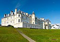
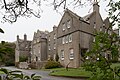 Dunskey House
 -
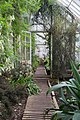 Dunskey House Greenhouse
 -
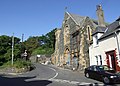 School Brae, Portpatrick
 -
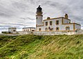 Killantringan Lighthouse
 -
 Portpatrick Hotel
 -
 Dunskey Castle


.jpg)
.jpg)

.jpg)


- 9 North Crescent, Crown Hotel
- Dunskey, Gatepiers, Gates, and Boundary Walls to South Lodge
- Portpatrick Harbour Including Outer and Inner Harbour with Lifting Crane, Lifeboat Shed and Warehouse, South Pier, Lighthouse, Lightkeeper's Cottage and Old Lighthouse Pottery
- Dunskey Castle
- 51 Main Street, Anglesea including Boundary Walls
- Deans place, Mansewood including Boundary Walls, Railings, and Gate
- 1 Dinvin Street including Boundary Walls and Gatepiers
- Dunskey Gatepiers, Gates and Boundary Walls to North Lodge
- 4-6A (Even Nos) Main Street
- 21 And 23 Main Street, Gannochy and Burnbrae including Railings
- Dunskey, Gatepiers and Boundary Walls
- Portree Bridge
- 29 Main Street, Ivy Cottage and Garden Flat including Boundary Walls and Railings
- Dunskey, Dunskey House including Sundial
- High Auchenree
- 7 North Crescent including Boundary Walls
- 21 South Crescent, Carlton House
- 23 South Crescent, Erinview
- 35 Main Street
- 8 Main Street, Cowanlea
- St Patrick Street, Inglenook including Boundary Walls and Gatepiers
- Dunskey, Cable House
- School Brae, Portpatrick Church Hall (former Free Church) including Boundary Walls, Railings and Gate
- Killantringan Lighthouse and Keeper's Cottage including Foghorn, Outbuildings, Boundary Walls and Gatepiers
- Holm Street, Portpatrick Parish Church (Church of Scotland) including Boundary Walls, Gatepiers and Gates
- Dunskey, Home Farm
- Braefield Road, Braefield House including Boundary Walls and Railings
- Dunskey, South Lodge
- North Crescent, Harbourside and Craigview including Boundary Walls and Railings
- 13 and 15 North Crescent, Lorac and Smugglers Cove, including Boundary Walls and Railings
- 25 South Crescent, Ardbeg
- Dunskey, The Stables (formerly Dunskey Gardener's Cottages)
- Dunskey, Kennels House and Kennels
- 25 Main Street, Commercial Inn including Railings, Boundary Walls and Gates
- Dunskey, Walled Garden and Greenhouses
- 10 and 12 Main Street, Downshire Arms Hotel
- Heugh Road, Portpatrick Hotel including Boundary Walls and Gatepiers
- St Patrick Street, Old Parish Church
- St Patrick Street, Old Parish Church Graveyard, Boundary Walls and Gates
- 53 Main Street, Harbour House Hotel
- 49 Main Street, Rockville including Boundary Walls
References
[eedit | eedit soorce]- ↑ "View: A map of the county of Wigton. - Counties of Scotland, 1580-1928 - National Library of Scotland". Maps.nls.uk. Retrieved 23 Mairch 2014.
- ↑ "Portpatrick Map". Scottish-places.info. Retrieved 23 Mairch 2014.
- ↑ "Portpatrick Community Council Home". Portpatrick-communitycouncil.org.uk. Archived frae the original on 23 Mairch 2014. Retrieved 23 Mairch 2014.
- ↑ "Portpatrick Lifeboat week 2012". Portpatrick Holiday Cottage. 24 Juin 2012. Archived frae the original on 23 Mairch 2014. Retrieved 23 Mairch 2014.
- ↑ "Dunskey Castle: Listed Building Report". Historic Scotland. Retrieved 3 September 2013.[deid airtin]
- ↑ Archaeological and Historical Collections relating to Ayrshire and Galloway. vol.V. pp.62-73
- ↑ Stubbs, Martin. "Meteorological services provided in the context of Safety of Life at Sea – Frequently asked questions". Retrieved 29 Julie 2007.
- ↑ "Extended Outlook". Retrieved 21 Julie 2016.
Forder readin
[eedit | eedit soorce]- Brack, Arthur: 1997 Irregular Marriages Portpatrick, Wigtownshire 1759-1826 (Clogher Historical Society; transcription of Irish entries in register)