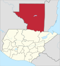
Petén Depairtment
Appearance
El Petén | |
|---|---|
Depairtment | |
 El Petén | |
| Coordinates: 16°54′N 89°54′W / 16.900°N 89.900°W | |
| Kintra | |
| Depairtment | El Petén |
| Caipital | Flores |
| Municipalities | 12 |
| Govrenment | |
| • Teep | Departmental |
| Area | |
| • Depairtment | 35854 km2 (13,843 sq mi) |
| Population (Census 2002)[1] | |
| • Depairtment | 366,735 |
| • Urban | 110,399 |
| • Ethnicities | Ladino Mopan Lacandon Itza Q'eqchi' |
| • Religions | Roman Catholicism Evangelicalism |
| Time zone | -6 |
Petén is a depairtment o the naition o Guatemala. It is geographically the northmaist depairtment o Guatemala, as well as the lairgest in size — at 12,960 square mile (33,600 km2) it accoonts for aboot ane third o Guatemala's aurie. The caipital is Flores. The population in 2005 wis estimatit at 450,000.
Notes
[eedit | eedit soorce]- ↑ "XI Censo Nacional de Poblacion y VI de Habitación (Censo 2002)". INE. 2002. Archived frae the original on 20 October 2008. Retrieved 22 August 2012.


