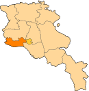
Parakar
Appearance
Parakar Փարաքար | |
|---|---|
| Coordinates: 40°09′50″N 44°24′21″E / 40.16389°N 44.40583°E | |
| Kintra | Armenie |
| Province | Armavir |
| Population (2008) | |
| • Total | 5,193 |
Parakar (Armenie: Փարաքար, Romanisit as P’arak’ar; umwhile, Shirabad) is a toun in the Armavir Province o Armenie. The 2001 census for the hale commonty, that includes the naurhaun toun o Tairov, wis 7,211. The toun haes a gypsum mine an its Saunt Harutyun kirk dates frae 1855.
References
[eedit | eedit soorce]- Parakar at GEOnet Names Server
- World Gazeteer: Armenia[deid airtin] – World-Gazetteer.com
- Report of the results of the 2001 Armenian Census, Naitional Statistical Service o the Republic o Armenie
- Brady Kiesling, Rediscovering Armenia, p. 32; oreeginal airchived at Archive.org, an current version online on Armeniapedia.org.


