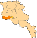
Getashen, Armavir
Appearance
Getashen Գետաշեն | |
|---|---|
| Coordinates: 40°02′36″N 43°56′41″E / 40.04333°N 43.94472°E | |
| Kintra | Armenia |
| Marz (Province) | Armavir |
| Population (2008) | |
| • Total | 2,296 |
| Time zone | UTC+4 ( ) |
| • Summer (DST) | UTC+5 ( ) |
Getashen (Armenie: Գետաշեն; an aw, Kalagar; till 1946, Dzhafarabat an Jafarabad[1]) is a toun in the Armavir Province o Armenie on the border wi Turkey.
References
[eedit | eedit soorce]- ↑ Kiesling, Rediscoving Armenia, p. 38, available online at the US embassy to Armenia's website Archived 2008-06-26 at the Wayback Machine
- Getashen, Armavir at GEOnet Names Server
- World Gazeteer: Armenia[deid airtin] – World-Gazetteer.com
- Report of the results of the 2001 Armenian Census, Naitional Statistical Service o the Republic o Armenie
Freemit airtins
[eedit | eedit soorce]- Գյուղացին չի կարողանում եւ չի ուզում մշակել հողը[deid airtin], an article in Hetq Online about the troubles of farmers in Getashen (in Armenie)


