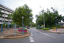
Palmerston, Northren Territory
| Palmerston Northren Territory | |
|---|---|
 Palmerston central business destrict | |
| Coordinates | 12°28′50″S 130°58′59″E / 12.48056°S 130.98306°ECoordinates: 12°28′50″S 130°58′59″E / 12.48056°S 130.98306°E |
| Population | 27,618 (2011)[1] |
| • Density | 9.1/km2 (24/sq mi) |
| Established | 1981 |
| Postcode(s) | 0830 |
| Aurie | 52.9 km2 (20.4 sq mi) |
| Time zone | ACST (UTC+9:30) |
| Location | |
| LGA(s) | Ceety o Palmerston |
| Coonty | Coonty o Palmerston |
| Territory electorate(s) | |
| Federal Diveesion(s) | Solomon |
Palmerston is a planned satellite ceety o Darwin, the caipital an lairgest ceety in Australie’s Northren Territory. Palmerston is situatit near Darwin Harbour an haes an urban population o 23,614 on the 2006 Census nicht an makin it the seicont lairgest ceety in the territory. Palmerston is currently the fastest growin ceety in the Northren Territory an haes briefly in the past held the title o the fastest growin ceety in Australie.
There are 18 suburbs aw thegither in Palmerston, 10 o which are close tae the Palmerston ceety centre. Palmerston is maistly residential wi twa licht industrial auries in the north o the ceety.
Like the rest o the Top End, Palmerston haes a tropical climate, wi a wet saison an a dry saison. It receives hivy rainfaw durin the Wet, an is well-kent for its spectacular lichtnin.
References
[eedit | eedit soorce]- ↑ Australian Bureau of Statistics (31 October 2012). "Palmerston (Statistical Area Level 3)". 2011 Census QuickStats. Retrieved 12 Mey 2013.

