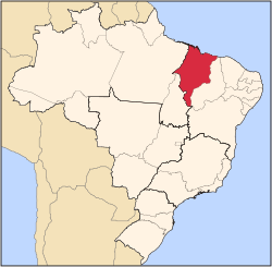
Maranhão
State o Maranhão | |
|---|---|
 Location o State o Maranhão in Brazil | |
| Coordinates: 6°11′S 45°37′W / 6.183°S 45.617°W | |
| Kintra | |
| Caipital an Lairgest Ceety | São Luís |
| Govrenment | |
| • Govrenor | Roseana Sarney |
| • Vice Govrenor | João Alberto |
| Area | |
| • Total | 331983.293 km2 (128,179.466 sq mi) |
| Area rank | 8t |
| Population (2010 census)[1] | |
| • Total | 6,569,683 |
| • Rank | 10t |
| • Density | 20/km2 (51/sq mi) |
| • Density rank | 16t |
| Demonym(s) | Maranhense |
| GDP | |
| • Year | 2006 estimate |
| • Total | R$ 28,621,000,000 (16t) |
| • Per caipita | R$ 4,628 (26t) |
| HDI | |
| • Year | 2005 |
| • Category | 0.683 – medium (26t) |
| Time zone | UTC-3 (BRT) |
| • Summer (DST) | UTC-2 (BRST) |
| Postal Code | 65000-000 tae 65990-000 |
| ISO 3166 code | BR-MA |
| Website | ma.gov.br |
Maranhão (locally: [maɾɐˈɲɐ̃w][2]) is a northeastren state o Brazil. Tae the north lees the Atlantic Ocean. Maranhão is neeboured bi the (clockwise frae east) states o Piauí, Tocantins an Pará. The fowk o Maranhão hae a destinctive accent inside the common Northeastren Brazilian dialect. Maranhão is described in beuks such as The Land o the Palm Trees, bi Gonçalves Dias, an Casas de Pensão bi Aluísio Azevedo.
The dunes o Lençóis are an important aurie o environmental preservation. An aw o interest is the state caipital o São Luís, designatit a UNESCO Warld Heritage Steid. Anither important conservation aurie is the Parnaíba River delta, atween the states o Maranhão an Piauí, wi its lagoons, desert dunes an desertit beaches or islands, such as the Caju island, which shelters rare birds.
Notes
[eedit | eedit soorce]- ↑ Censo 2010: população do Brasil é de 190.732.694 pessoas
- ↑ In the variety o Brazilian Portuguese spoken in Rio de Janeiro, it is [maɾɐ̃ˈȷ̃ɐ̃w]. The European Portuguese pronunciation is [mɐɾɐˈɲɐ̃w].
Freemit airtins
[eedit | eedit soorce]- (in Portuguese) Offeecial wabsteid Archived 2021-08-20 at the Wayback Machine
| This Brazil location airticle is a stub. Ye can help Wikipaedia bi expandin it. |

