Itaparica, Bahia
Tuils
Actions
General
Prent/export
In ither projects
Appearance
Frae Wikipedia, the free beuk o knawledge
Itaparica | |
|---|---|
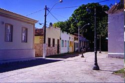
 A street in Itaparica. | |
 Location in the state o Bahia an Brazil | |
| Coordinates: 12°53′16″S 38°40′44″W / 12.88778°S 38.67889°W / -12.88778; -38.67889 | |
| Kintra | Brazil |
| Region | Northeast |
| State | Bahia |
| Govrenment | |
| • Mayor | Vicente Gonçalves da Silva (PSDB) |
| Area | |
| • Total | 115.922 km2 (44.758 sq mi) |
| Population (2008)[1] | |
| • Total | 20,641 |
| • Density | 187.9/km2 (487/sq mi) |
| Time zone | UTC-3 (UTC-3) |
| • Summer (DST) | UTC-2 (UTC-2) |
| Website | Prefeitura Municipal de Itaparica |
Itaparica is a ceety locatit in the Brazilian island o the same name in the state o Bahia.
References
[eedit | eedit soorce]Freemit airtins
[eedit | eedit soorce]- Itaparica Ceety Haw Archived 2008-12-26 at the Wayback Machine

