Guayabal de Síquima
Guayabal de Síquima | |
|---|---|
Municipality an toun | |
 | |
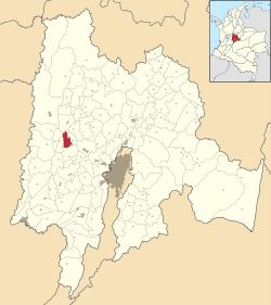
 Location o the municipality an toun inside Cundinamarca Depairtment o Colombie | |
| Coordinates: 4°52′N 74°28′W / 4.867°N 74.467°WCoordinates: 4°52′N 74°28′W / 4.867°N 74.467°W | |
| Kintra | |
| Depairtment | |
| Elevation | 1630 m (5,350 ft) |
| Time zone | UTC-5 (Colombie Staundart Time) |
Guayabal de Síquima forbye kent as "The Gowden Gate o the Central Magdalena" is a municipality an toun o Colombia in the depairtment o Cundinamarca locatit in the Central Magdalena Province 69 km frae Bogotá.
The principal toun is locatit at 4°52’52” north an 74°28’10” wast, in zone cried Wastren Zone o the Eastren Muntains, which is characterisit bi sinuous muntains.
Guayabal de Síquima is bordered on the northeast bi the municipality o Villeta, on the wast bi the municipality o Bituima, on the north bi Albán an on the sooth bi Anolaima.
History
[eedit | eedit soorce]Guayabal de Síquima wis foondit in 1721 wi the assignation o the Father Luis Calvo Vasallo as pairish priest o the toun. He began the construction o 22 hooses o Bareque an 5 o mud waw steppit aroond the Principal Pairk.
In the year o 1739 Guayabal de Síquima wis dividit intae fower big zones Chiniata, namit in honour o auncient Indie leader or Cacique, El Trigo (the wheat), bein this region whaur this grain wis cultivatit for the first time; Resguardo, in memory o which the natives cried Muizane, meanin refuge or defence, an Manoa in memory o auncient "cacique" o the region.


