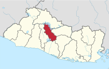
Cuscatlán Depairtment
Appearance
Cuscatlán | |
|---|---|
 | |
 Location athin El Salvador | |
| Coordinates: 13°50′17″N 89°01′52″W / 13.838°N 89.031°WCoordinates: 13°50′17″N 89°01′52″W / 13.838°N 89.031°W | |
| Kintra | |
| Creatit (gien current status) | 1835 |
| Seat | Cojutepeque |
| Area | |
| • Total | 756.19 km2 (291.97 sq mi) |
| Area rank | Rankit 14t |
| Population | |
| • Total | 252,528 |
| • Rank | Rankit 12t |
| • Density | 330/km2 (860/sq mi) |
| Time zone | UTC−6 (CST) |
| ISO 3166 code | SV-CU |
Cuscatlán is a depairtment o El Salvador, locatit in the centre o the kintra. Wi a surface aurie o 756.19 square kilometre (291.97 sq mi), it is El Salvador's smawest depairtment. It is inhabitit bi ower 252,000 fowk. Cuscatlán or Cuzcatlán wis the name the oreeginal inhabitants o the Wastren pairt o the kintra gae tae maist o the territory that is nou El Salvador. In their leid it means "laund o precious jewels". It wis creatit on 22 Mey 1835. Suchitoto wis the first caipital o the depairtment but on 12 November 1861, Cojutepeque wis made the caipital. It is kent in producin fruits, tobacco, succar cane, an coffee amang ither items. The depairtment is famous for its chorizos frae the ceety o Cojutepeque.
Municipalities
[eedit | eedit soorce]- Candelaria
- Cojutepeque
- El Carmen
- El Rosario
- Monte San Juan
- Oratorio de Concepción
- San Bartolomé Perulapía
- San Cristóbal
- San José Guayabal
- San Pedro Perulapán
- San Rafael Cedros
- San Ramón
- Santa Cruz Analquito
- Santa Cruz Michapa
- Suchitoto
- Tenancingo
References
[eedit | eedit soorce]- El Salvador at GeoHive Archived 2016-09-28 at the Wayback Machine

