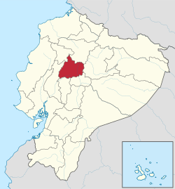
Cotopaxi Province
Appearance
Cotopaxi | |
|---|---|
| Province o Cotopaxi | |
 Location o Cotopaxi in Ecuador. | |
 Cantons o Cotopaxi Province | |
| Coordinates: 0°56′S 78°37′W / 0.933°S 78.617°W | |
| Kintra | Ecuador |
| Cantons | Leet o Cantons
|
| Govrenment | |
| • Provincial Prefect | César Umaginga |
| Area | |
| • Total | 5985 km2 (2,311 sq mi) |
| Population (2010) | |
| • Total | 406,798 |
| • Population 2001 | 356804 |
| Website | www.cotopaxi.gov.ec |

Cotopaxi is ane o the provinces o Ecuador. The caipital is Latacunga. The province contains the Cotopaxi Volcano, an intermittent volcano wi a hicht o 19,388 feet.
Cantons
[eedit | eedit soorce]The province is dividit intae 7 cantons.[1] The follaein table leets each canton wi its population (per the 2001 census), its aurie in square kilometres (km²), an the name o the canton seat (caipital).[2]
| Canton | Pop. (2001) | Aurie (km²) | Seat/Caipital |
|---|---|---|---|
| La Maná | 32,115 | 647 | La Maná |
| Latacunga | 143,979 | 1,377 | Latacunga |
| Pangua | 19,877 | 715 | El Corazón |
| Pujilí | 60,728 | 1,289 | Pujilí |
| Salcedo | 51,304 | 484 | San Miguel |
| Saquisilí | 20,815 | 206 | Saquisilí |
| Sigchos | 20,722 | 1,267 | Sigchos |
See an aw
[eedit | eedit soorce]| Wikimedia Commons haes media relatit tae Province of Cotopaxi. |
- Cotopaxi Naitional Pairk
- Llanganates Naitional Pairk
- Panzaleo (ethnic group)
- Provinces o Ecuador
- Cantons o Ecuador
References
[eedit | eedit soorce]- ↑ Danny Palmerlee, Michael Grosberg, Carolyn McCarthy (2006), Ecuador and the Galapagos Islands, Lonely Planet, ISBN 1-74104-295-XCS1 maint: multiple names: authors leet (link)
- ↑ Cantons of Ecuador. Statoids.com. Retrieved 4 November 2009.
Freemit airtins
[eedit | eedit soorce]- (in Spaingie) Gobierno Provincia de Cotopaxi Archived 2009-12-10 at the Wayback Machine, offeecial wabsteid
- Cotopaxi Tours Archived 2018-08-21 at the Wayback Machine

