Kırıkkale Province
Kırıkkale Province Kırıkkale ili | |
|---|---|
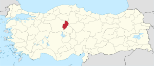
 Location of Kırıkkale Province in Turkey | |
| Kintra | Turkey |
| Region | Central Anatolie |
| Govrenment | |
| • Electoral destrict | Kırıkkale |
| Area | |
| • Tot | 4,365 km2 (1,685 sq mi) |
| Population (2010)[1] | |
| • Tot | 277,984 |
| • Density | 64/km2 (160/sq mi) |
| Area code(s) | 0318 |
| Vehicle registration | 71 |
Kırıkkale Province (Turkis: Kırıkkale ili) is a province o Turkey. It is locatit on the crossroads o major heich-gates east o Ankara leadin east tae the Black Sea region. Wi its rapid population growthe it haes acome an industrial centre. The provincial caipital is Kırıkkale.
Kırıkkale is a rapidly growin toun in central Turkey, on the Ankara-Kayseri railwey near the Kızılırmak River. Umwhile a veelage, it awes its rapid rise in population mainly tae the establishment o steel mills in the 1950s. Thir wirks, amang the lairgest in the kintra, specialize in heich-quality alloy steel an machinery. In the 1960s chemical plants wur addit.
Destricts[eedit | eedit soorce]
Kırıkkale province is dividit intae 9 destricts (caipital destrict in bauld):
Gallery[eedit | eedit soorce]
Image:Delice Irmak valey near Yeni Yapan.jpg|
References[eedit | eedit soorce]
- ↑ Turkish Statistical Institute, MS Excel document – Population of province/district centers and towns/villages and population growth rate by provinces
Freemit airtins[eedit | eedit soorce]
| Wikimedia Commons haes media relatit tae Kırıkkale Province. |
- (in Turkis) Kırıkkale govrenor's offeecial wabsteid
- (in Turkis) Kırıkkale municipality's offeecial wabsteid
- (in Inglis) Kırıkkale weather forecast information Archived 2011-08-24 at the Wayback Machine

