
Greater Lunnon
| Coonty | |
| Sovereign state | Unitit Kinrick |
|---|---|
| Constituent kintra | Ingland |
| Region | Lunnon |
| Ceremonial coonty | |
| Area | [convert: needs a number] |
| • Rankit | o 48 |
| • Rankit | o 48 |
| Density | [convert: needs a number] |
| Ethnicity | 69% white |
| Time zone | Greenwich Mean Time (UTC) |
| • Simmer (DST) | Breetish Simmer Time (UTC+1) |
Greater Lunnon (Inglis: Greater London) is the tap-level admeenistrative diveesion o Ingland coverin Lunnon. It wis creatit in 1965 an spans the Ceety o Lunnon, includin Middle Temple an Inner Temple, an the 32 Lunnon boroughs. This territory is coterminate wi the Lunnon Govrenment Office Region an the Lunnon European Parliament constituency. The region haes bi far the heichest GDP per caipita in the Unitit Kinrick. It covers 1572 km2 (607 square miles) an haed a 2009 mid-year estimatit population o 7,753,600. The term Greater Lunnon wis in uise afore 1965 tae refer tae a variously defined aurie, lairger than the Coonty o Lunnon an aften seemilar tae the Metropolitan Police District.
In addition tae its admeenistrative an statistical functions, Greater Lunnon (excludin the Ceety o Lunnon) is ane o the 48 ceremonial coonties o Ingland, an is unner the Greater Lunnon Lieutenancy.
History[eedit | eedit soorce]
Insteid o formin a single poleetical unit, Lunnon is dividit intae the sma, interior Ceety o Lunnon an the hinter wider Greater Lunnon. This arrangement haes come aboot acause as the aurie o Lunnon grew an absorbed neighbourin settlements, a series o admeenistrative reforms did no fully amalgamate the Ceety o Lunnon wi the metropolitan aurie, an its unique poleetical structur wis retained. Ootside the leemitit bundaries o the auld ceety, a variety o arrangements govrened the wider aurie syne 1855, culminatin wi the creation o the Greater Lunnon admeenistrative aurie in 1965.
Oreegins[eedit | eedit soorce]
The term Greater Lunnon haed been uised well afore 1965, parteecularly tae refer tae the aurie covered bi the Metropolitan Police District (sic as in the 1901 census), the aurie o the Metropolitan Water Board (favoured bi the Lunnon Coonty Cooncil for statistics), the Lunnon Passenger Transport Aurie an the aurie defined bi the Registrar General as the Greater Lunnon Conurbation.
The Greater Lunnon Arterial Road Programme wis devised atween 1913 an 1916. Ane o the lairger early forms wis the Greater Lunnon Planning Region, devised in 1927, which occupee'd 1,856 square miles (4,810 km2) an included 9 million fowk. It wis historically kent as Inglon.
Ryal Commission on Lunnon Govrenment[eedit | eedit soorce]

Awtho the Lunnon Coonty Cooncil haed been creatit as a Lunnon-wide authority coverin the Coonty o Lunnon in 1889, the Coonty did no even kiver aw the biggit-up aurie o Lunnon then, pairticularly Wast Ham an East Ham; furthermair mony o the LCC hoosin projects, includin the vast Becontree Estate, wur constructit ootside its formal bundaries.
Lunnon Coonty Cooncil pressed for an alteration in its bundaries suin efter the end o the First Warld War, notin that athin the Metropolitan an Ceety Police Districts thare wur 122 hoosin authorities. A Ryal Commission on Lunnon Govrenment wis set up tae consider the issue. Lunnon Coonty Cooncil proposed a vast new Greater Lunnon, somewhaur atween the Metropolitan Police District an the entire Hame Coonties. Protests wur made at the possibility o includin Windsor, Slough an Eton in the authority.
The Commission made its report in 1923, rejectin the LCC's scheme. Twa minority reports favoured chynge ayont the amalgamation o smawer urban destricts, includin baith smawer borough cooncils an a Central Authority for strategic functions. The Lunnon Traffic Act 1924 wis a result o the Commission.
Creation o admeenistrative aurie[eedit | eedit soorce]
Reform o the local govrenment arrangements in the Coonty o Lunnon an its environs wis again considered bi the Ryal Commission on Local Govrenment in Greater Lunnon. Greater Lunnon wis formally creatit bi the Lunnon Govrenment Act 1963, which teuk force on 1 Aprile 1965, replacin the umwhile admeenistrative coonties o Middlesex an Lunnon, addin the Ceety o Lunnon, which wis no unner the Lunnon Coonty Cooncil, an absorbin pairts o Kent, Surrey, Essex an Hertfordshire.
Greater Lunnon oreeginally haed a twa-tier seestem o local govrenment, wi the Greater Lunnon Cooncil (GLC) sharin pouer wi the Ceety o Lunnon Corporation (govrenin the sma Ceety o Lunnon) an the 32 Lunnon borough cooncils. The Greater Lunnon Cooncil wis abolished in 1986 bi the Local Govrenment Act 1985. Its functions wur devolved tae the Corporation an the Lunnon boroughs wi some functions transferred tae central govrenment an jynt boards.
Greater Lunnon Authority[eedit | eedit soorce]
Greater Lunnon wis uised tae form the Lunnon region o Ingland in 1994. A referendum held in 1998, established public will tae creaut a regional authority. The Greater Lunnon Authority, Lunnon Assembly an the directly elected Mayor of London war creatit in 2000 bi the Greater Lunnon Authority Act 1999.
The 2000 an 2004 mayoral elections wur baith wan bi Ken Livingstone, who haed been the feenal leader o the GLC. The 2008 election wis wan bi Boris Johnson the Conservative Pairty candidate. In 2000 the ooter bundary o the Metropolitan Police District wis re-aligned tae the Greater Lunnon bundary.
Geography[eedit | eedit soorce]
Greater Lunnon is bundit bi the hame coonties o Essex an Hertfordshire in the East o Ingland region an Buckinghamshire, Berkshire, Surrey an Kent in Sooth East Ingland. The heichest pynt in Greater Lunnon is Westerham Heights, in the North Douns an on the bundary wi Kent, at 245 metres (804 ft).
The aurie o Greater Lunnon haes no chynged significantly syne its creation. Thare hae been a considerable nummer o smaw bundary chynges. The maist significant o thir wur the 1969 transfers o Knockholt tae Kent an Farleigh tae Surrey an a series o minor adjustments durin the 1990s which realigned the bundary tae the M25 motorwey in some places. The majority o Greater Lunnon forms the Lunnon low emission zone frae 4 Februar 2008.
Govrenance[eedit | eedit soorce]

Greater Lunnon is no a ceety in the proper sense that the wird applies in the Unitit Kinrick, that o bein a status grantit bi the Croun. In addition, ane o the Lunnon burghs, Westminster, is awready a ceety, as well as the Ceety o Lunnon itsel which wad mak sic a status anomalous. Despite this, Greater Lunnon is commonly regardit as a ceety in the general sense o a municipality. A Laird Lieutenant o Greater Lunnon is appointit for its aurie, less the Ceety o Lunnon, an aurie identical tae the Metropolitan Police District, and for the purposes o the Lieutenancies Act 1997, this aurie is defined as a coonty.
The term "Lunnon" is normally uised in reference tae Greater Lunnon or tae the owera conurbation, but no aften tae the auncient, tiny Ceety o Lunnon. Insteid, this sma aurie is aften referred tae simply as "the Ceety" or "the Square Mile" an it forms the main financial destrict. Airchaically the urbanised aurie o Lunnon wis kent as the Metropolis. In common uisage, the terms "Lunnon" an "Greater Lunnon" are uisually uised interchyngeably. It is offeecially dividit for some purposes, wi varyin definitions, intae Inner Lunnon an Ooter Lunnon. For strategic plannin purposes the region is dividit intae five sub regions.
Strategic local govrenment[eedit | eedit soorce]
Greater Lunnon is unner the strategic local governance o the Greater Lunnon Authority. The Greater Lunnon Authority (GLA) comprises an electit assembly cried the Lunnon Assembly an an executive heid kent as the Mayor o Lunnon.
Local govrenment[eedit | eedit soorce]
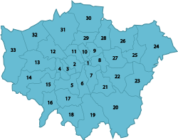
Greater Lunnon is dividit intae 32 Lunnon burghs, each govrened bi a Lunnon burgh cooncil; an the Ceety o Lunnon, which haes a unique govrenment datin back tae the 12t century.
Aw Lunnon borough cooncils belang tae the Lunnon Cooncils association. Twa Lunnon burghs, Kensington and Chelsea, an Kingston, cairy the purely honorific title o Ryal burgh. Athin the Ceety o Lunnon bundary are the liberties o Middle Temple an Inner Temple.
 |
Lunnon Assembly[eedit | eedit soorce]
For elections tae the Lunnon Assembly, Lunnon is dividit intae fowerteen constituencies. The constituencies are formed frae the aurie o twa or three boroughs combined. The Ceety o Lunnon forms pairt o the Ceety an East constituency.
UK Parliament[eedit | eedit soorce]
Lunnon is dividit intae 73 Parliamentary constituencies, which are aw sma burgh constituencies. Thay are formed frae the combined aurie o several wards frae ane or mair Lunnon Burghs. teepically a single burgh is covered bi twa or three constituencies.
Economy[eedit | eedit soorce]
This is a chairt o trend o regional gross value addit (GVA) o Inner Lunnon at current basic prices published (pp. 240–253) bi Office for National Statistics wi figures in millions o Breetish Punds Sterlin.
| Year | Regional Gross Value Addit | Agricultur | Industry | Services |
|---|---|---|---|---|
| 1995 | 64,616 | 7 | 8,147 | 56,461 |
| 2000 | 92,330 | 6 | 10,094 | 82,229 |
| 2003 | 112,090 | 12 | 10,154 | 101,924 |
This is a chairt o trend o regional gross value addit o Ooter Lunnon at current basic prices published (pp. 240–253) bi Office for National Statistics wi figures in millions o Breetish Punds Sterlin.
| Year | Regional Gross Value Addit | Agricultur | Industry | Services |
|---|---|---|---|---|
| 1995 | 44,160 | 51 | 10,801 | 33,307 |
| 2000 | 60,304 | 43 | 12,529 | 47,732 |
| 2003 | 67,582 | 39 | 13,081 | 54,462 |
Twinnin[eedit | eedit soorce]
The Greater Lunnon Authority haes twin an sister ceety agreements wi the follaein ceeties.
| Kintra | Ceety | Coonty / Destrict / Region / State | Date | |
|---|---|---|---|---|
| Cheenae | Beijing | Beijing Municipality | 2006 | |
| Fraunce | Paris | Île-de-France | ||
| Germany | Berlin | Berlin | 2000 | |
| Roushie | Moscow | Central Federal Destrict | ||
| Unitit States | New York Ceety | New York | 2001 | |
| Japan | Tokyo | Tokyo | 2005 |
For Burgh twinnin see Leet o twin touns an sister ceeties in the Unitit Kinrick#Lunnon.
References & notes[eedit | eedit soorce]
Notes[eedit | eedit soorce]
References[eedit | eedit soorce]
Freemit airtins[eedit | eedit soorce]
- Greater Lunnon Authority
- Greater Lunnon Online Archived 2016-02-21 at the Wayback Machine - Lunnon Community News, Information an Business Directory
- Greater Lunnon Business Community Directory[deid airtin]
- Greater Lunnon at Curlie
- Airticles wi deid fremmit airtins frae January 2021
- Greater Lunnon
- Geografie o Lunnon
- NUTS 1 statistical regions o Ingland
- Local govrenment in Lunnon
- Metropolitan auries o Ingland
- NUTS 1 statistical regions o the European Union
- Interestit pairties in plannin in the Unitit Kinrick
- Coonties o Ingland established in 1965