Villa García
Appearance
Villa García - Manga Rural | |
|---|---|
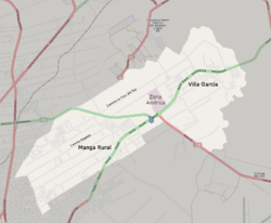
 Street map o Villa García - Manga Rural | |
 Location o Villa García - Manga Rural in Montevideo | |
| Coordinates: 34°47′S 56°03′W / 34.783°S 56.050°WCoordinates: 34°47′S 56°03′W / 34.783°S 56.050°W | |
| Kintra | |
| Depairtment | Montevideo Depairtment |
| Ceety | Montevideo |
Villa García - Manga Rural is a barrio (neebourheid or destrict) o Montevideo, Uruguay.
Umwhile thare wis a important agricultural schuil here, established bi Juan D. Jackson. Nouadays it haes been transformit in the Jacksonville development.[1]
Places of worship
[eedit | eedit soorce]- Christ o Toledo Pairish Kirk, Ruta 8 Nº 9303 (Roman Catholic)
- St. Joseph o Manga Chapel, in Jacksonville (Roman Catholic)
- Pairish Kirk o St. Lawrence, Cno. Repetto 3937 (Roman Catholic, Salesian Sisters o Don Bosco)
See an aw
[eedit | eedit soorce]References
[eedit | eedit soorce]- ↑ History of Jacksonville Archived 2012-11-22 at the Wayback Machine (in Spaingie)
Freemit airtins
[eedit | eedit soorce]- Offeecial steid o Villa García Archived 2011-10-04 at the Wayback Machine
- Revista Raíces/ Historia del barrio Manga
- Public school of Manga Rural on Camino Repetto 2952-3996 Archived 2015-11-06 at the Wayback Machine
- "Cultural landscape of Villa Garcia" (PDF) (in Spanish). Facultad de Arquitectura - UdelaR. Archived frae the original (PDF) on 4 Mairch 2016. Retrieved 10 Mey 2013.CS1 maint: unrecognised leid (link)

