Tuzla Canton
Tuzla Canton
Tuzlanski kanton[1] | |
|---|---|
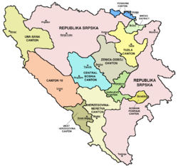
 Location o the Tuzla Canton | |
| Coordinates: 44°33′N 18°36′E / 44.550°N 18.600°E | |
| Kintra | Bosnie an Herzegovinae |
| Entity | Federation o Bosnie an Herzegovinae |
| Main ceety | Tuzla |
| Municipalities | |
| Govrenment | |
| • Prime Meenister | Bahrija Umihanić |
| Area | |
| • Total | 2649.0 km2 (1,022.8 sq mi) |
| Population (2013 census)[2] | |
| • Total | 477,278 |
| • Density | 180,17/km2 (46,660/sq mi) |
| ISO 3166 code | BA-03 |
| Website | http://www.vladatk.kim.ba/ |

The Tuzla Canton, offeecially the Tuzla Canton[1] (Bosnie: Tuzlanski kanton[1]) is the third o 10 cantons o the Federation o Bosnie an Herzegovinae, ane o twa entities in Bosnie an Herzegovinae. The cantonal seat is in Tuzla.
Municipalities
[eedit | eedit soorce]The Tuzla Canton comprises the municipalities o Banovići, Čelić, Doboj Istok (Doboj East), Gradačac, Gračanica, Kladanj, Kalesija, Lukavac, Sapna, Srebrenik, Teočak an Živinice, as well as the ceety o Tuzla.
History an cultur
[eedit | eedit soorce]The canton wis creatit bi the Washington Agreement in 1994, an its boundaries defined bi the Dayton Agreement in 1995.
The Srebrenik Fortress is Bosnia's best-preserved medieval fort, datin frae 1333 an is locatit in Srebrenik.
Tuzla is the hip hop centre o the Balkans due tae Edo Maajka, Frenkie an the first hip hop station in Bosnie, which is locatit in Tuzla, FMJAM. Muisic airtist guitarist Emir Het, pianist Bešlić, accordionist Emir Vildić an violinist Selma Dizdarević are frae Tuzla an aw. Famous sangsters Selma Bajrami an Lepa Brena wur baith born in Tuzla
See an aw
[eedit | eedit soorce]References
[eedit | eedit soorce]- ↑ a b c The Constitution of the Tuzla Canton Archived 2012-03-30 at the Wayback Machine Official name of canton is Tuzla Canton
- ↑ "First release" (PDF). Federal Office of Statistics, Federation of Bosnia and Herzegovina. 30 Juin 2011. Archived frae the original (PDF) on 11 Mey 2013. Retrieved 12 December 2014.


