Alagoas
Appearance
(Reguidit frae State o Alagoas)
State o Alagoas | |
|---|---|
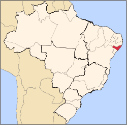
 Location o State o Alagoas in Brazil | |
| Kintra | |
| Caipital an Lairgest Ceety | Maceió |
| Govrenment | |
| • Governor | Teotônio Brandão Vilela Filho (PSDB) |
| • Vice Govrenor | José Thomaz Nonô |
| Area | |
| • Total | 27767.661 km2 (10,721.154 sq mi) |
| Area rank | 25t |
| Population (2010 census)[1] | |
| • Total | 3,120,922 |
| • Rank | 16t |
| • Density | 110/km2 (290/sq mi) |
| • Density rank | 4t |
| Demonym(s) | Alagoano |
| GDP | |
| • Year | 2006 estimate |
| • Total | R$ 15,753,000,000 (20th) |
| • Per capita | R$ 5,164 (25th) |
| HDI | |
| • Year | 2005 |
| • Category | 0.677 – laich (27t) |
| Time zone | UTC-3 (BRT) |
| • Summer (DST) | UTC-2 (BRST) |
| Postal Code | 57000-000 to 57990-000 |
| ISO 3166 code | BR-AL |
Alagoas (Portuguese pronunciation: [alɐˈgoɐs][2]) is ane o the 27 states o Brazil an is situatit in the eastren pairt o the Northeast Region. It borders: Pernambuco (N and NW); Sergipe (S); Bahia (SW); an the Atlantic Ocean (E). It occupees an aurie o 27,767 km², being slichtly lairger than Haiti. Its caipital is the ceety o Maceió.
It is made up o 102 municipalities an its maist populous ceeties are Maceió, Arapiraca, Palmeira dos Índios, Rio Largo, Penedo, União dos Palmares, São Miguel dos Campos, Santana do Ipanema, Delmiro Gouveia, Coruripe, Marechal Deodoro, an Campo Alegre.
Notes
[eedit | eedit soorce]- ↑ Censo 2010: população do Brasil é de 190.732.694 pessoas
- ↑ It is pronooncit as [alɐˈgoɐʃ ~ ɐlɐˈgow.ɐjʃ] in Rio de Janeiro an [alɐˈgoajs] in São Paulo. The European Portuguese pronunciation is [ɐlɐˈɣoɐʃ].


