San Pascual, Batangas
Appearance
San Pascual | |
|---|---|
 San Pascual Municipal Hall | |
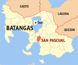
 Map o Batangas showin the location o San Pascual | |
| Coordinates: 13°48′27″N 121°02′31″E / 13.80750°N 121.04194°E | |
| Kintra | Philippines |
| Region | CALABARZON (Region IV-A) |
| Province | Batangas |
| Destrict | 2nd District |
| Foondit | 1932 |
| Barangays | 29 |
| Govrenment | |
| • Mayor | Antonio Dimayuga |
| Area | |
| • Total | 50.70 km2 (19.58 sq mi) |
| Population (2010)[3] | |
| • Total | 59,598 |
| • Density | 1,200/km2 (3,000/sq mi) |
| Time zone | UTC+8 (PST) |
| ZIP code | 4204 |
| Dialin code | 43 |
| Income class | 1st class |
San Pascual is a first class municipality in the province o Batangas, Philippines. Accordin tae the 2010 census, it haes a population o 59,598 fowk.[3]
San Pascual wis umwhile pairt o the municipality o Bauan an kent as "Lagnas". It became an unthirlt municipality in 1969. The municipality is adjacent tae Batangas Ceety, alang Batangas Bay. The toun is hame tae a ile refinery an chemical plants as well as ither industrial an commercial establishments.
Barangays
[eedit | eedit soorce]San Pascual is poleetically subdividit intae 29 barangays.[2]
- Alalum
- Antipolo
- Balimbing
- Banaba
- Bayanan
- Danglayan
- Del Pilar
- Gelerang Kawayan
- Ilat North
- Ilat South
- Kaingin
- Laurel
- Malaking Pook
- Mataas Na Lupa
- Natunuan North
- Natunuan South
- Padre Castillo
- Palsahingin
- Pila
- Poblacion
- Pook Ni Banal
- Pook Ni Kapitan
- Resplandor
- Sambat
- San Antonio
- San Mariano
- San Mateo
- Santa Elena
- Sto. Nino
Demographics
[eedit | eedit soorce]| Population census of San Pascual | ||
|---|---|---|
| Year | Pop. | ±% p.a. |
| 1990 | 34,629 | — |
| 1995 | 40,849 | +3.36% |
| 2000 | 49,041 | +3.72% |
| 2007 | 57,200 | +2.22% |
| 2010 | 59,598 | +1.38% |
| Source: National Statistics Office[3] | ||
References
[eedit | eedit soorce]- ↑ "Official City/Municipal 2013 Election Results". Intramuros, Manila, Philippines: Commission on Elections (COMELEC). 11 September 2013. Retrieved 11 November 2013.
- ↑ a b "Province: BATANGAS". PSGC Interactive. Makati City, Philippines: National Statistical Coordination Board. Archived frae the original on 14 November 2012. Retrieved 11 November 2013.
- ↑ a b c "Total Population by Province, City, Municipality and Barangay: as of May 1, 2010" (PDF). 2010 Census of Population and Housing. National Statistics Office. Archived frae the original (PDF) on 29 October 2013. Retrieved 11 November 2013.
Freemit airtins
[eedit | eedit soorce]| Wikimedia Commons haes media relatit tae San Pascual, Batangas. |
- Offeecial Wabsteid o the Local Govrenment o the Municipality o San Pascual Archived 2007-09-30 at the Wayback Machine
- Philippine Standard Geographic Code Archived 2012-04-13 at the Wayback Machine
- Philippine Census Information Archived 2013-10-04 at the Wayback Machine


