
San Cristóbal Acasaguastlán
San Cristóbal Acasaguastlán | |
|---|---|
Municipality | |
 San Cristóbal Acasaguastlán Location in Guatemala | |
| Coordinates: 14°55′08″N 89°52′20″W / 14.91889°N 89.87222°W | |
| Kintra | |
| Depairtment | El Progreso |
| Govrenment | |
| • Teep | Municipal |
| Area | |
| • Municipality | 124 km2 (48 sq mi) |
| Elevation | 250 m (820 ft) |
| Highest elevation | 2110 m (6,920 ft) |
| Lowest elevation | 250 m (820 ft) |
| Population (Census 2002)[1] | |
| • Municipality | 6,129 |
| • Urban | 1,846 |
| • Religions | Roman Catholicism Evangelicalism |
| Time zone | UTC-6 |
| Website | Municipality steid |
San Cristóbal Acasaguastlán (Spaingie pronunciation: [san kɾisˈtoβal akasaɣwaskaˈtlan]) is a toun in the El Progreso depairtment o Guatemala. San Cristóbal Acasaguastlán is locatit on the northren bank o the Motagua River at a altitude o 250 m. It haed a population o 6,129 fowk at the 2002 census,[1] an covers a territory o 124 square kilometre (48 sq mi).[2] San Cristóbal Acasaguastlán borders on San Agustín Acasaguastlán tae the northwast, Usumatlán tae the east, an El Jicaro tae the sooth. It is locatit on the inter-ocean heich-gate (CA-9), 101 km frae Guatemala Ceety.
History
[eedit | eedit soorce]San Cristóbal Acasaguastlán's history haes its oreegins in Mayan cultur; its fowk are associatit wi the culturs o Copán an Quiriguá. In the nint an tent hunderyears AD, the Nahuas settled in the vicinity o San Cristóbal Acasaguastlán, beginnin a cultural mixtur leadin tae their indigenous leid (Alaguilac). At the time o the Spainyie conquest the toun o San Cristobal wis foondit, drivin the aboreeginal fowks frae their toun tae scattered dounsets in the muntains. At the time o conquest, the toun o Acasaguastlán wis a holy an sacred place for the Indians. It did no hae major construction, anerly moonds as in Guaytán. The Spainyie uised the prehistoric Acasaguastlán province for their toun o San Cristobal; its central square wis the steid for ane o the pro-unthirldom riots o 1812. Efter Guatemala gained its unthirldom frae Spain in 1821, San Cristóbal Acasaguastlán belangit tae the Zacapa Depairtment unner Decree 683 o 13 Apryle 1908; wi Legislative Decree 1965 o 3 Apryle 1934 the new Depairtment o El Progreso wis established, which includit San Cristóbal Acasaguastlán. Twa o the finest examples o 16t-hunderyear Baroque airchitectur can be foond in San Agustín Acasaguastlán an San Cristóbal Acasaguastlán in El Progreso.
Eddication
[eedit | eedit soorce]San Cristobal is currently (as o 2011) the anerly municipality in Guatemala reportin a 100% leeteracy rate.
Kirk
[eedit | eedit soorce]The colonial Cathedral o San Cristobal o 1654 is bein restored, an promises tae be on a par wi the cathedrals an kirks foond in Antigua Guatemala. The restoration project haes been unnertaken tae undae damage caused bi the yirdquauk o 1976.
References
[eedit | eedit soorce]- ↑ a b "XI Censo Nacional de Poblacion y VI de Habitación (Censo 2002)". INE. 2002. Archived frae the original on 20 October 2008. Retrieved 9 October 2014.
- ↑ San Cristóbal Acasaguastlán. Municipality of San Cristóbal Acasaguastlán.
Further readin
[eedit | eedit soorce]- Feldman, Lawrence H. (2000). Motagua Colonial: Conquest and Colonization in the Motagua River Valley in Guatemala. Raleigh: Boson Books/C&M Online Media. p. 200. ISBN 1-886420-51-3. Archived frae the original on 16 October 2012. Retrieved 9 October 2014. Cite has empty unkent parameter:
|coauthors=(help) - McNally, Shelagh. Adventure Guide to Guatemala (Adventure Guides Series). Grand Rapids: Hunter (NJ), 2003.
- Oss, Adriaan C. van. Catholic Colonialism: A Parish History of Guatemala, 1524-1821 (Cambridge Latin American Studies). New York: Cambridge UP, 2002.
Freemit airtins
[eedit | eedit soorce]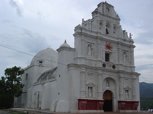
Caipital: Guastatoya | ||
| Municipalities |  | |