Salina Cruz
Salina Cruz | |
|---|---|
Municipality and town | |
 | |
 Location of the municipality in Oaxaca | |
| Coordinates: 16°10′N 95°12′W / 16.167°N 95.200°W | |
| Country | |
| State | Oaxaca |
| Area | |
| • Total | 113.55 km2 (43.84 sq mi) |
| Population (2005) | |
| • Total | 76,219 |
| Time zone | UTC-6 (Central Staundart Time) |
| • Summer (DST) | UTC-5 (Central Daylicht Time) |
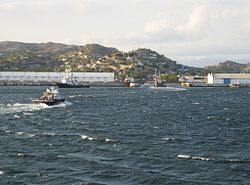
Salina Cruz is a major seaport on the Pacific coast o the Mexican state o Oaxaca. It is the state's third-lairgest ceety an is municipal seat o the municipality o the same name. It is pairt o the Tehuantepec Destrict in the wast o the Istmo Region. The ceety haed a 2005 census population o 71,314 indwallers, while its municipality, wi an aurie o 113.55 km2 (43.84 sq mi) haed a population o 76,219, the state's fowert-lairgest municipality in population.
The port wis developit in the late 19t hunderyear due tae its location at the soothren terminus o the Ferrocarril Transístmico, which carriet freicht athort the Isthmus o Tehuantepec.

History
[eedit | eedit soorce]Salina Cruz is situatit near the mooth o the Río Tehuantepec, on the open coast o the Isthmus o Tehuantepec on the Gulf o Tehuantepec, an haes nae naitural harbour. Thare wis anerly a smaw Native veelage afore Salina Cruz wis chosen as the Paceefic terminus o the Ferrocarril Transístmico, whaurupon a modren toun wis laid oot an biggit on adjacent heicher grund an a airtificial harbour wis biggit bi the Mexican govrenment tae accommodate the expectit traffec. The new port wis opened tae traffec in 1907 an in 1909 its population wis lairgely componit o labourers. The harbour wis shapit bi the construction o twa breakwatters, the wastren 3,260 ft (990 m) an the eastren 1,900 ft (580 m) lang, which curve toward ilk ither at thair ooter extremities an leave a entrance 635 ft (194 m) wide. The enclosed space is dividit intae a ooter an inner harbour bi a dooble line o quays wide enough tae cairy sax great warehooses wi electric cranes on baith sides an a nummer o railwey tracks. Connectit wi the new port wirks wis ane o the then-lairgest dry docks in the warld 610 ft (190 m) lang an 89 ft (27 m) wide, wi a deth o 28 ft (8.5 m) on its sill at law watter. The wirks wur planned tae haundle an immense volume o transcontinental freicht, an afore thay wur feenished fower steamship lines haed arrangit regular caws at Salina Cruz.
The municipality
[eedit | eedit soorce]As municipal seat, Salina Cruz haes govrenin jurisdiction ower the follaein commonties:
Agua Blanca, Boca del Río, Colonia el Bosque, Colonia el Mirador, Colonia Estibadores, Colonia Granadillo, Colonia la Brecha, Colonia Miramar, Colonia Santita, Colonia Vista Hermosa, El Ciruelo, El Puentecito, Ensenada de la Ventosa, La Brecha (Rancho Moisés Aquino), La Hacienda (Palo Grande), Las Escolleras, Palo Grande, Playa Azul, Playa Brasil (Brasilito), Salinas del Marqués, San Antonio Monterrey, an San José del Palmar
Popular cultur
[eedit | eedit soorce]Salina Cruz featurs as the focus for the novel Last Stop Salina Cruz (2007) bi Breetish novelist David Lalé. The novel tells the story o a young man follaein in the fuitpaths o modrenist legend Arthur Cravan athort Fraunce, Spain, USA, Mexico an feenally Salina Cruz.
See an aw
[eedit | eedit soorce]References
[eedit | eedit soorce] This airticle incorporates text frae a publication nou in the public domain: Chisholm, Hugh, ed. (1911). "article name needed". Encyclopædia Britannica (11th ed.). Cambridge University Press. Cite has empty unkent parameters:
 |HIDE_PARAMETER15=,|HIDE_PARAMETER13=,|HIDE_PARAMETER14c=,|HIDE_PARAMETER14=,|HIDE_PARAMETER9=,|HIDE_PARAMETER3=,|HIDE_PARAMETER1=,|HIDE_PARAMETER4=,|HIDE_PARAMETER2=,|HIDE_PARAMETER8=,|HIDE_PARAMETER20=,|HIDE_PARAMETER5=,|HIDE_PARAMETER7=,|HIDE_PARAMETER10=,|separator=,|HIDE_PARAMETER14b=,|HIDE_PARAMETER6=,|HIDE_PARAMETER11=, and|HIDE_PARAMETER12=(help)CS1 maint: ref=harv (link)- Link to tables of population data from Census of 2005 INEGI: Instituto Nacional de Estadística, Geografía e Informática
- Oaxaca Archived 2011-05-17 at the Wayback Machine Enciclopedia de los Municipios de México
Freemit airtins
[eedit | eedit soorce]- Municipio de Salina Cruz Archived 2007-05-03 at the Wayback Machine Offeecial wabsteid
- Info about Salina Cruz Archived 2012-09-27 at the Wayback Machine Regional wabsteid
- Page relatit tae Salina Cruz History and folklore Archived 2007-05-28 at the Wayback Machine General Information
- Port o Salina Cruz Archived 2011-02-04 at the Wayback Machine
- Review of Last Stop Salina Cruz on The Independent
- Last Stop Salina Cruz on Amazon


