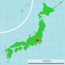
Saitama Prefectur
Appearance
Saitama Prefecture 埼玉県 | |
|---|---|
| Japanese transcription(s) | |
| • Japanese | 埼玉県 |
| • Rōmaji | Saitama-ken |
 | |
| Coordinates: 35°57′N 139°33′E / 35.950°N 139.550°ECoordinates: 35°57′N 139°33′E / 35.950°N 139.550°E | |
| Kintra | Japan |
| Region | Kantō |
| Island | Honshu |
| Caipital | Saitama |
| Govrenment | |
| • Govrenor | Kiyoshi Ueda |
| Area | |
| • Total | 3,797.00 km2 (1,466.03 sq mi) |
| Area rank | 39t |
| Population (1 September 2010) | |
| • Total | 7,190,817 |
| • Rank | 5th |
| • Density | 1893.82/km2 (4,905.0/sq mi) |
| ISO 3166 code | JP-11 |
| Destricts | 8 |
| Municipalities | 63 |
| Flouer | Primrose (Primula sieboldii) |
| Tree | Keyaki (Zelkova serrata) |
| Bird | Eurasian collared dove (Streptopelia decaocto) |
| Website | www.pref.saitama.lg.jp/ index_e.html |
Saitama Prefectur (Japanese: 埼玉県, transleet. Saitama-ken) is a prefectur o Japan locatit in the Kantō region o the island o Honshu.[1] The caipital ceety is Saitama.[2]
This prefectur is pairt o the Greater Tokyo Aurie, an maist o Saitama's ceeties can be describit as suburbs o Tokyo, tae which a muckle amoont o residents commute ilka day.
Notes
[eedit | eedit soorce]- ↑ Nussbaum, Louis-Frédéric. (2005). "Saitama prefecture" in Japan Encyclopedia, p. 808 at Google Books; "Kantō" in p. 479 at Google Books.
- ↑ Saitama City Profile, overview
Freemit airtins
[eedit | eedit soorce]| Wikimedia Commons haes media relatit tae Saitama prefecture. |


