Lippe
Lippe | |
|---|---|
 | |
| Kintra | |
| State | North Rhine-Westphalie |
| Adm. region | Detmold |
| Caipital | Detmold |
| Area | |
| • Total | 1,246.4 km2 (481.2 sq mi) |
| Population (31 December 2021)[1] | |
| • Total | 346,151 |
| • Density | 280/km2 (720/sq mi) |
| Time zone | UTC+1 (CET) |
| • Summer (DST) | UTC+2 (CEST) |
| Vehicle registration | LIP |
| Website | http://www.lippe.de |
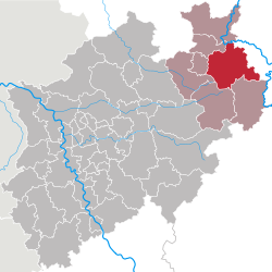
Lippe (German pronunciation: [ˈlɪpə]) is a Kreis (destrict) in the east o North Rhine-Westphalie, Germany. Neebourin destricts are Herford, Minden-Lübbecke, Höxter, Paderborn, Gütersloh, an destrict-free Bielefeld, which forms the region Ostwestfalen-Lippe.
The destrict o Lippe is namit efter the Lairds o Lippe an their Principality o Lippe. It wis a state athin the Holy Roman Empire an retained stateheid till 1947, when it became a destrict o North Rhine-Westphalie.
History
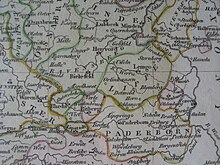
[eedit | eedit soorce]The Lippe destrict nearly covers the same aurie as the historic coonty o Lippe. The first mention o this kintra wis in 1123; it grew in pouer slowly in the follaein centuries. In 1528 it became a coonty, in 1789 it wis elevatit tae a principality.

Unlike mony ither kintras o the Holy Roman Empire in the aurie, Lippe kept its unthirldom in the Napoleonic era, an thus wisna incorporatit intae Proushie efterwairds. It was one of the smaller member states of the German empire.
Efter the daith o Prince Woldemar in 1895, the twa lines o the Hoose o Lippe focht ower the regency for ower a decade.
The last prince o Lippe wis forcit aeo abdicate in 1918 efter the end o Warld War I when Germany became a republic; his kintra became a Freistaat in the German republic. In 1932 the Free State o Lippe wis subdividit intae twa destricts, Detmold an Lemgo. These continued tae exist when in 1947 Lippe lost its status as a state o Germany an bi order o the Breetish militar govrenment wis incorporatit intae the new federal state North Rhine-Westphalie; in 1949 this chynge wis appruivit bi the pairlament. In 1969/70 the 168 ceeties an municipalities wur mergit tae 16; an as the seicont pairt o the admeenistrative reform in 1973 the twa destricts Lemgo an Detmold wur mergit tae the destrict Lippe.
Geografie
[eedit | eedit soorce]The Lippe destrict covers the northren pairt o the Teutoburg Forest, which contain the heichest elevation o the destrict an aw, the 496 meter heich Köterberg near Lügde. The lawest elevation is at the Weser river wi 45.5 m. The main river is the Werre, an at the northren border o the destrict the Weser.
Coat o airms
[eedit | eedit soorce]
|
The coat o airms shows the tradeetional seembol o the state o Lippe, the rose, as the destrict covers nearly the same aurie as the historic kintra. In the middle o the rose 16 stamens seembolize the 16 ceeties an municipalities o the destrict. The coat o airms wis grantit in 1973.
Despite the relatively smaw size o Lippe, the Lippish rose is ane o anerly three seembols includit in the coat o airms o the state o North Rhine-Westphalie an aw. |
Touns an municipalities
[eedit | eedit soorce]| Touns | Municipalities |
|---|---|
Culinar art
[eedit | eedit soorce]The maist famous dish servit in Lippe is the Pickert. In the past it wis kent as a meal for poor fowk. The main ingredients are potatoes, flour an raisins.
References
[eedit | eedit soorce]- ↑ "Bevölkerung der Gemeinden Nordrhein-Westfalens am 31. Dezember 2021" (in German). Landesbetrieb Information und Technik NRW. Retrieved 20 Juin 2022.
Freemit airtins
[eedit | eedit soorce]![]() Media relatit tae Kreis Lippe at Wikimedia Commons
Media relatit tae Kreis Lippe at Wikimedia Commons
- Offeecial wabsteid Archived 2013-07-18 at the Wayback Machine (in German)
- Ordinances an bi-laws o the coonty o Lippe online[deid airtin]
- Guidelines for the integration o the Land Lippe athin the territory o the federal state North-Rhine-Westphalie o 17 Januar 1947[deid airtin]
 . Catholic Encyclopedia. New York: Robert Appleton Company. 1913. Cite has empty unkent parameter:
 |HIDE_PARAMETER=(help) - Releegious history o Lippe frae the Reformation till the early twintiet century

