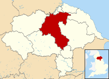
Hambleton
Coordinates: 54°20′02″N 1°25′44″W / 54.334°N 1.429°W
Hambleton District | |
|---|---|
Destrict | |
 Shown athin North Yorkshire | |
| Sovereign state | Unitit Kinrick |
| Constituent kintra | Ingland |
| Region | Yorkshire an the Humber |
| Admeenistrative coonty | North Yorkshire |
| Admeen. HQ | Northallerton |
| Govrenment | |
| • Teep | Hambleton District Council |
| • Leadership: | Leader & Cabinet |
| • Executive: | Conservative |
| • MPs: | Rishi Sunak, Kevin Hollinrake |
| Area | |
| • Total | 1311 km2 (506 sq mi) |
| Area rank | 14t |
| Population (2011 est.) | |
| • Total | 90,690 |
| • Rank | Rankit 265t |
| • Density | 69/km2 (180/sq mi) |
| Time zone | UTC+0 (Greenwich Mean Time) |
| • Summer (DST) | UTC+1 (Breetish Simmer Time) |
| ONS code | 36UC (ONS) E07000164 (GSS) |
| Ethnicity | 99.2% White |
| Website | hambleton.gov.uk |
Hambleton is a local govrenment destrict o North Yorkshire, England. The main toun an admeenistrative centre is Northallerton, an includes the mercat touns an major veelages o Bedale, Thirsk, Great Ayton, Stokesley an Easingwold.
The district wis shapit bi the Local Govrenment Act 1972 on 1 Apryle 1974, as a merger o the urban destrict o Northallerton wi Bedale Rural District, Easingwold Rural District, Northallerton Rural District, an pairt o Thirsk Rural District, Stokesley Rural District an Croft Rural District, aw in the North Riding of Yorkshire.
Geografie
[eedit | eedit soorce]
Hambleton covers a aurie o 1,311.17 km² maist o which, 1,254.90 km², is green space.[1] The destrict is namit efter the Hambleton Hills, pairt o the North York Moors Naitional Pairk, on the eastren edge o the destrict. This aurie is the subject o a naitional habitat protection scheme as airticulatit in the Unitit Kinrick's Biodiversity Action Plan.
Touns
[eedit | eedit soorce]Population Size
1. Northallerton
2. Thirsk
3. Bedale
4. Easingwold
Demographics
[eedit | eedit soorce]

In 2007 Hambleton haed an estimatit population o 86,900 an increase o 3.2% on the population o 84,200 recordit in the 2001 UK census.[2] In the 2001 census 83% o respondents identifee'd their releegion as Christians abuin the naitional average for Ingland which wis 71.74%. Nae ither releegion accoontit for mair nor 0.2% o the population wi the next twa lairgest groups o respondents whaur those wi nae releegion, at 10.40%, an who did no state a releegion, at 6.14%.[3]
Energy policy
[eedit | eedit soorce]In Mey 2006, a report commissioned bi British Gas[4] showed that hoosin in Hambleton producit the 8t heichest average carbon emissions in the kintra at 7,242 kg o carbon dioxide per dwellin. Whilst this haes come unner some scrutiny, it is important tae remember that due tae the remote natur o the cooncils pairishes (Great Langton, Scorton etc.) carbon emissions are likely tae be heich.
References
[eedit | eedit soorce]- ↑ United Kingdom Census 2001 (2001). "Hambleton (Local Authority): Key Figures for Physical Environment". neighbourhood.statistics.gov.uk. Archived frae the original on 3 Mairch 2016. Retrieved 10 December 2008.
- ↑ Performance, Research & Intelligence Team Chief Executive's Group (2007). "Population Estimates 2007 Parish". Page 5. North Yorkshire County Council. Archived frae the original (pdf) on 7 August 2011. Retrieved 9 December 2008.
- ↑ United Kingdom Census 2001 (2001). "Hambleton (Local Authority)". neighbourhood.statistics.gov.uk. Archived frae the original on 3 Mairch 2016. Retrieved 9 December 2008.
- ↑ http://www.britishgasnews.co.uk/managed_content/files/pdf/greenCity.pdf Archived 2008-06-26 at the Wayback Machine britishgasnews.co.uk
Further readin
[eedit | eedit soorce]- Golisti K.O.M. (1998) Hambleton and it's History. Ashdown Products. ISBN 0952195054
Freemit airtins
[eedit | eedit soorce]| Wikimedia Commons haes media relatit tae Hambleton. |
