Casabó
Casabó - Pajas Blancas | |
|---|---|
 Main street in Pajas Blancas | |
 Oweraw map o Casabó - Pajas Blancas | |
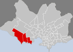
 Location o Casabó - Pajas Blancas in Montevideo | |
| Coordinates: 34°52′0″S 56°18′30″W / 34.86667°S 56.30833°W | |
| Kintra | |
| Depairtment | Montevideo Depairtment |
| Ceety | Montevideo |
| Time zone | UTC -3 |
| Postal code | 12800 & 12700 |
| Dial plan | +598 2 (+7 digits) |
Casabó - Pajas Blancas is a barrio (neebourheid or destrict) o Montevideo, Uruguay. It shares borders wi Paso de la Arena tae the north an northwast, wi La Paloma - Tomkinson tae the northeast, wi Villa del Cerro tae the east an is delimitit bi the Río de la Plata tae the sooth.
Casabó
[eedit | eedit soorce]34°53′0″S 56°16′0″W / 34.88333°S 56.26667°W
Casabó is the wastren extension o the Villa del Cerro an it includes the Fortaleza del Cerro, the Parque Dr. Carlos Vaz Ferreira an the ruins o the cauld storage factory Frigorífico Swift, the shut doun Frigorífico Nacional, the Club de Golf del Cerro an the an aurie o the Navy. Tae the wast o Casabó is the barrio o Santa Catalina, situatit next tae the beach an the public pairk o Punta Yeguas.
Pajas Blancas
[eedit | eedit soorce]34°52′0″S 56°20′0″W / 34.86667°S 56.33333°W
Pajas Blancas is a veelage an resort aboot 7.5 kilometre (4.7 mi) wast o Casabó. It stairtit as a seaside resort which gained permanent inhabitants. It haes twa beaches: Playa Pajas Blancas an Playa Zabala. An abandoned hotel bi the beach, the Viejo Hotel, used to host important events, includin the festivities for o the Selección Uruguaya when they wan the fitbaa cup in 1930.
In 2004, it haed 1,976 inhabitants.[1] This number is no includit in the population coont o the ceety o Montevideo.
| Year | Population |
|---|---|
| 1963 | 925 |
| 1975 | 921 |
| 1985 | 1,257 |
| 1996 | 1,837 |
| 2004 | 1,976 |
Source: Instituto Nacional de Estadística de Uruguay[2]
Street maps
[eedit | eedit soorce] |
 |
Photos
[eedit | eedit soorce]
References
[eedit | eedit soorce]- ↑ "2004 Census of Montevideo department". INE. 2004. Archived frae the original (XLS) on 3 December 2011. Retrieved 4 Julie 2011.
- ↑ "1963–1996 Statistics / P". Instituto Nacional de Estadística de Uruguay. 2004. Archived frae the original (DOC) on 21 Julie 2011. Retrieved 4 Julie 2011. Italic or bold markup not allowed in:
|publisher=(help)
See an aw
[eedit | eedit soorce]| Wikimedia Commons haes media relatit tae Casabo, Pajas Blancas. |

