Tungurahua Province
Tungurahua | |
|---|---|
Province | |
| Province o Tungurahua | |
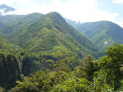
 Landscape near Baños | |
 Tungurahua Province in Ecuador | |
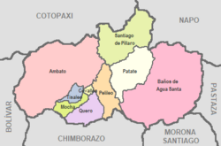
 Cantons o Tungurahua Province | |
| Coordinates: 1°14′S 78°37′W / 1.233°S 78.617°W | |
| Kintra | Ecuador |
| Caipital | Ambato |
| Cantons | Leet o cantons
|
| Govrenment | |
| • Provincial Prefect | Fernando Naranjo (Unidad Intercultural) |
| Area | |
| • Total | 3371 km2 (1,302 sq mi) |
| Elevation | 2600 m (8,500 ft) |
| Highest elevation | 5016 m (16,457 ft) |
| Lowest elevation | 900 m (3,000 ft) |
| Population (2011)INEC decadal national census | |
| • Total | 581,389 |
| Time zone | UTC-5 (ECT) |
Tungurahua (Spaingie: Provincia del Tungurahua, literally Province o the Tungurahua) is ane o the twinty-fower provinces o Ecuador. Its caipital is Ambato. The province taks its name frae the Tungurahua volcano, which is locatit athin the boondaries o the provinces.
Population
[eedit | eedit soorce]As o 2011, Tungurahua haed an estimatit population o 581,389.[1] Approximately 10% o that population is made up o indigenous fowks, while anither 70% are o mestizo or mixed race heritage. The feenal 20% is made up o fowks o African, Asie, an European ancestry.
Climate
[eedit | eedit soorce]The province haes a dry, temperate climate. Lik aw muntainous auries, the region experiences the phenomenon kent as microclimates in which sma portions o the province receive drastically different conditions frae ithers due tae winds an aurie pressur. Generally tho, Tungurahua experiences temperaturs in-atween 14 an 17 degree Celsius in the day-time wi ceuler nichts. At heicher altitudes, conditions are obviously much caulder. Despite bein near the Equator, muntains lik Carihuayrazo an Chimborazo are covered in snaw for hintle o the year.[2]
Geografie
[eedit | eedit soorce]The province is vera muntainous, containin the Tungurahua volcano near Baños as well as borderin the Carihuayrazo an Chimborazo volcanoes tae the sooth. Baños is the biggest tourist destination. The principal river o the province is the Patate River which flows tae the east toward the Amazon Region.[1]
Poleetical diveesion
[eedit | eedit soorce]The province is dividit intae nine cantons which stretch frae Ambato in the wast tae Baños in the east. The follaein table leets each wi its population as o the 2001 census, its aurie in square kilometres (km²), an the name o the canton seat or caipital.[3]
| Canton | Pop. (2011) | Aurie (km²) | Seat/Caipital |
|---|---|---|---|
| Ambato | 387,282 | 1,009 | Ambato (San Juan de Ambato) |
| Baños | 19,112 | 1,065 | Baños (Baños de Agua Santa) |
| Cevallos | 8,873 | 19 | Cevallos |
| Mocha | 8,371 | 86 | Mocha |
| Patate | 16,771 | 315 | Patate |
| Pelileo | 58,988 | 202 | Pelileo (San Pedro de Pelileo) |
| Píllaro | 44,925 | 443 | Píllaro (Santiago de Píllaro) |
| Quero | 23,187 | 173 | Quero (Santiago de Quero) |
| Tisaleo | 14,525 | 59 | Tisaleo |
Places o interest
[eedit | eedit soorce]- Parque de la Familia
- Llanganates Naitional Pairk
See an aw
[eedit | eedit soorce]References
[eedit | eedit soorce]- ↑ a b Population of the Honorable Consejo Provincial de Tungurahua Archived 2009-04-12 at the Wayback Machine. 21 July 2009.
- ↑ Territory of the Honorable Consejo Provincial de Tungurahua Archived 2009-08-28 at the Wayback Machine. 21 July 2009.
- ↑ Cantons of Ecuador. Statoids.com. Retrieved 4 November 2009.

