Sopron
Sopron
| |
|---|---|
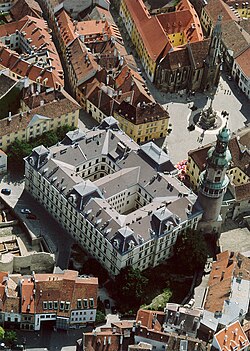
 Aerial photograph o the Ceety Haw an the Main square | |
| Coordinates: 47°41′06″N 16°34′59″E / 47.68489°N 16.58305°E | |
| Kintra | |
| Coonty | Győr-Moson-Sopron |
| Govrenment | |
| • Mayor | Tamás Fodor (Fidesz-KDNP) |
| Area | |
| • Total | 169.01 km2 (65.26 sq mi) |
| Population (2012) | |
| • Total | 61,390 |
| • Rank | 18t |
| • Density | 353.04/km2 (914.4/sq mi) |
| Population bi ethnicity | |
| • Hungarians | 92.8% |
| • Germans | 3.5% |
| • Croats | 1.7% |
| • Ithers | 2% |
| Time zone | UTC+1 (CET) |
| • Summer (DST) | UTC+2 (CEST) |
| Postal code | 9400 |
| Area code(s) | 99 |
Sopron (Hungarian pronunciation: [ˈʃopron]; German: Ödenburg, Croatie: Šopron, Laitin: Scarbantia) is a ceety in Hungary on the Austrian border, near the Loch Neusiedl/Loch Fertő.
Airchitectur
[eedit | eedit soorce]The airchitectur o the auld section o toun reflects its lang history; waws an fundations frae the Roman Empire are still common, thegither wi a walth o Medieval, Renaissance, an Baroque structurs, aften airtistically decoratit, showin centuries o stability an prosperity.
There is an auld synagogue an ither remains frae the toun's umwhile Jewish commonty, which wis expelled in the 16t century.
On Daloshegy, thare is a 165 metres taw FM-/TV-broadcasting touer, which leuks like a rocket an haes tharefore the elk-name "Rakéta" (Hungarian for rocket).
Internaitional relations
[eedit | eedit soorce]Twin touns — sister ceeties
[eedit | eedit soorce]Sopron is twinned wi:
| Wikimedia Commons haes media relatit tae Sopron. |


