Santiago Province, Chile
Appearance
Santiago Province Provincia de Santiago | |
|---|---|
 Alameda del Libertador Bernardo O'Higgins, a lairge boulevard in dountoun Santiago. | |
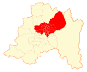
 Location in the Santiago Metropolitan Region | |
| Coordinates: 33°25′S 70°33′W / 33.417°S 70.550°W | |
| Kintra | Chile |
| Region | Santiago Metropolitan |
| Caipital | Santiago |
| Communes | Leet o 32 |
| Area | |
| • Total | 2030.3 km2 (783.9 sq mi) |
| Area rank | 4 |
| Population (2002 Census)[1] | |
| • Total | 4,668,473 |
| • Rank | 1 |
| • Density | 2,300/km2 (6,000/sq mi) |
| • Urban | 4658687 |
| • Rural | 9786 |
| Sex | |
| • Men | 2,244,497 |
| • Weemen | 2,423,976 |
| Time zone | UTC−4 (CLT) |
| • Summer (DST) | UTC−3 (CLST) |
| Area code | 56 + 2 |
Santiago Province (Spaingie: Provincia de Santiago) is ane o the sax provinces o the Santiago Metropolitan Region (RM) o central Chile. It encompasses the majority o the population o that region, includin 31 o the 36 communities o Greater Santiago. The province spans 2,030.3 km (1,262 mi).[1]
Footnotes
[eedit | eedit soorce]- ↑ a b c d (in Spaingie) Instituto Nacional de Estadísticas
References
[eedit | eedit soorce]- This airticle draws hivily on the corresponding airticle in the Spaingie-leid Wikipaedia, which wis accessed in the version o 28 November 2005.


