Rio Negro (Amazon)
Appearance
| Negro River (Río Negro) | |
| Guainía River | |
Sunset ower the Rio Negro, upstream frae Manaus
| |
| Kintras | Brazil, Colombie, Venezuela |
|---|---|
| Tributaries | |
| - left | Branco River (an mony smawer rivers) |
| - right | Vaupés River (an mony smawer rivers) |
| Soorce | heichlands o Colombie |
| - location | Guainía Depairtment, Amazon region, Colombie |
| Mooth | Amazon River |
| - location | Manaus, Amazonas State, Brazil |
| - coordinates | 3°08′00″S 59°54′30″W / 3.13333°S 59.90833°WCoordinates: 3°08′00″S 59°54′30″W / 3.13333°S 59.90833°W |
| Lenth | 2,250 km (1,400 mi) [1] |
| Basin | 691,000 km2 (267,000 sq mi) |
| Discharge | for mooth |
| - average | 28,000 m3/s (988,800 cu ft/s) [2] |
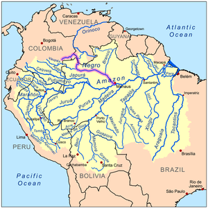
Cairt shawin the Rio Negro in the Amazon Basin
| |
The Rio Negro (Portuguese: Rio Negro [ˈʁi.u nɛɡɾu]; Spaingie: Río Negro [ˈri.o ˈneɣɾo] "Black River") is the lairgest left tributary o the Amazon, the lairgest blackwatter river in the warld, an ane o the warld's ten lairgest rivers in average discharge.
References
[eedit | eedit soorce]- ↑ Ziesler, R.; Ardizzone, G.D. (1979). "Amazon River System". The Inland waters of Latin America. Food and Agriculture Organization of the United Nations. ISBN 92-5-000780-9. Archived frae the original on 8 November 2014. Retrieved 14 Mairch 2015. Unknown parameter
|deadurl=ignored (help) - ↑ Seyler, Patrick; Laurence Maurice-Bourgoin; Jean Loup Guyot. "Hydrological Control on the Temporal Variability of Trace Element Concentration in the Amazon River and its Main Tributaries". Geological Survey of Brazil (CPRM). Archived frae the original on 21 Julie 2011. Retrieved 24 Julie 2010.


