Karlsborg Municipality
Karlsborg Municipality Karlsborgs kommun | |
|---|---|
 | |
| Kintra | Swaden |
| Coonty | Västra Götaland Coonty |
| Seat | Karlsborg |
| Area | |
| • Total | 797.35 km2 (307.86 sq mi) |
| • Laund | 405.87 km2 (156.71 sq mi) |
| • Water | 391.48 km2 (151.15 sq mi) |
| Aurie as o Januar 1, 2014. | |
| Population (31 December 2021)[2] | |
| • Total | 6,965 |
| • Density | 8.7/km2 (23/sq mi) |
| Time zone | UTC+1 (CET) |
| • Summer (DST) | UTC+2 (CEST) |
| ISO 3166 code | SE |
| Province | Västergötland |
| Municipal code | 1446 |
| Website | www.karlsborg.se |
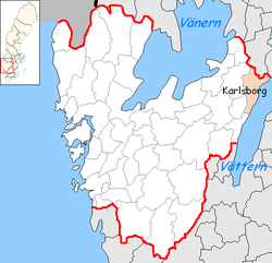
Karlsborg Municipality (Karlsborgs kommun) is a municipality in Västra Götaland Coonty in wastren Swaden. Its seat is locatit in the toun o Karlsborg.
The present municipality wis formit in 1971 when "auld" Karlsborg wis amalgamatit wi Mölltorp an Undenäs.
The aurie haes been dominatit bi Karlsborg Fortress an militar activity throughoot the last centuries.
Tiveden Naitional Pairk is pairtly situatit athin the municipality. The Flugebyn airfield, hame o the Västergötland Skydiving Club (Västergötlands Fallskärmsklubb) lees in the municipality an aw.

References[eedit | eedit soorce]
- ↑ "Statistiska centralbyrån, Kommunarealer den 1 januari 2014" (Microsoft Excel) (in Swadish). Stateestics Swaden. Retrieved 18 Apryle 2014.CS1 maint: unrecognised leid (link)
- ↑ "Folkmängd i riket, län och kommuner 31 december 2021" (in Swedish). Statistics Sweden. 22 Februar 2022. Retrieved 22 Februar 2022.CS1 maint: unrecognised leid (link)
Freemit airtins[eedit | eedit soorce]
- Karlsborg Municipality - Offeecial steid

