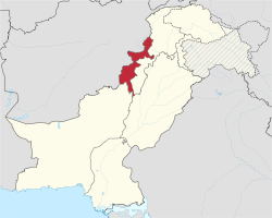
Federally Admeenistered Tribal Areas
Appearance
(Reguidit frae Federally Admeenistered Tribal Auries)
Federally Admeenistered Tribal Areas (Pashto: مرکزي قبایلي سیمې) | |
|---|---|
 Location o the Federally Admeenistered Tribal Areas | |
| Coordinates: 33°0′0″N 70°10′0″E / 33.00000°N 70.16667°E | |
| Kintra | Pakistan |
| Admeenistrative unit | Federal territory |
| Components | 7 Agencies 6 Frontier Regions |
| Admeenistrative centre | Peshawar |
| Govrenment | |
| • Govrenor o Khyber-Pakhtunkhwa | Syed Masood Kausar |
| Area | |
| • Total | 27220 km2 (10,510 sq mi) |
| Population | |
| • Total | 3,176,331 |
| • Density | 120/km2 (300/sq mi) |
| Time zone | UTC+5 (PST) |
| Website | http://www.fata.gov.pk/ |
The Federally Admeenistered Tribal Areas (FATA) (Pashto: مرکزي قبایلي سیمې) are a semi-autonomous tribal region in the northwast o Pakistan, lyin atween the province o Khyber Pakhtunkhwa, Balochistan, an the neighboring kintra o Afghanistan. The FATA comprise seiven Agencies (tribal destricts) an sax FRs(Frontier regions). The territory is amaist exclusively inhabitit bi Pashtun tribes which are predominantly Sunni Muslims bi faith.
References
[eedit | eedit soorce]- ↑ "Area, Population, Density and Urban/Rural Proportion by Administrative Units". Population Census Organization, Government of Pakistan. Archived frae the original on 22 December 2010. Retrieved 11 Apryle 2010.
- ↑ "Population". FATA Secretariat. Archived frae the original on 3 Mairch 2009. Retrieved 11 Apryle 2010.
Freemit airtins
[eedit | eedit soorce]- Constitutional Provisions on the Tribal Areas – Chapter 3, Part XII of the Constitution of Pakistan
- FATA Secretariat Official Website Archived 2012-09-18 at the Wayback Machine
- FATA Development Authority Official Website Archived 2013-05-12 at the Wayback Machine
 Travel guide tae Federally Admeenistered Tribal Areas frae Wikivoyage


