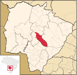
Campo Grande
Appearance
Coordinates: 20°27′44″S 54°36′40″W / 20.46222°S 54.61111°W
Campo Grande | |
|---|---|
Municipality | |
| The Municipality o Campo Grande | |
 | |
| Eik-name(s): Cidade Morena (Portuguese for "Brown Ceety"), CG, Campão (Big Field) | |
| Motto(s): "Poder, prosperidade e altruísmo" (Portuguese) "Power, prosperity and altruism" | |
 Location o Campo Grande | |
 | |
| Coordinates: 20°26′37″S 54°38′52″W / 20.44361°S 54.64778°W | |
| Kintra | |
| State | |
| Region | Center-Wast |
| Microregion | Campo Grande |
| Founded | 1899 |
| Govrenment | |
| • Mayor | Gilmar Olarte (PP) |
| Area | |
| • Municipality | 8096.05 km2 (3,125.90 sq mi) |
| • Urban | 154.5 km2 (59.7 sq mi) |
| Elevation | 592 m (1,942 ft) |
| Population (2014 census) | |
| • Municipality | 845.763 (20t) |
| • Density | 97.3/km2 (252/sq mi) |
| • Metro | 1,069,420 (20t) |
| Time zone | UTC-4 (UTC-4) |
| • Summer (DST) | UTC-3 (UTC-3) |
| Postal Code | 79000-000 |
| Area code(s) | (+55) 67 |
| Website | capital.ms.gov.br |
Campo Grande (Portuguese pronunciation: [ˈkɐ̃pu ˈɡɾɐ̃dʒi], Great Field) is the caipital an lairgest ceety o the Brazilian state o Mato Grosso do Sul in the Center-Wast region o the kintra.
Internaitional relations
[eedit | eedit soorce]Twin touns – Sister ceeties
[eedit | eedit soorce]Campo Grande is twinned wi:
References
[eedit | eedit soorce]- ↑ Pessotto, Lorenzo. "International Affairs - Twinnings and Agreements". International Affairs Service in cooperation with Servizio Telematico Pubblico. City of Torino. Archived frae the original on 18 Juin 2013. Retrieved 6 August 2013.


