Uiramutã
Uiramutã | |
|---|---|
| The Municipality o Uiramutã | |
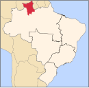
 Location o Uiramutã in the State o Roraima | |
| Coordinates: 04°35′45″N 60°10′04″W / 4.59583°N 60.16778°W | |
| Kintra | |
| Region | North |
| State | |
| Foondit | 17 October 1995 |
| Govrenment | |
| • Mayor | Florany Mota (PT) |
| Area | |
| • Total | 8066 km2 (3,114 sq mi) |
| Elevation | 804 m (2,638 ft) |
| Population (2008) | |
| • Total | 7,742 |
| • Density | 0.8/km2 (2/sq mi) |
| [1] | |
| Time zone | UTC-4 |
| HDI (2000) | 0.542 – medium[2] |
Uiramutã is a municipality locatit in the northeast o the state o Roraima in Brazil. Its population is 7,742 (as o 2008) an its aurie is 8,066 km². It is the northmaist ceety in Brazil, wi Monte Caburaí bein the northmaist point. Wast o this muntain, thare is the Monte Roraima an aw, the tawest muntain in Roraima and in Guyana, locatit in the triple frontier o Brazil, Guyana an Venezuela. The municipality is locatit entirely inside the Raposa Serra do Sol Indian Reservation.


