San Pedro Carchá
Appearance
San Pedro Carchá | |
|---|---|
Municipality | |
 Municipal palace, San Pedro Carchá | |
| Eik-name(s): Carchá | |
| Coordinates: 15°28′38″N 90°18′38″W / 15.47722°N 90.31056°W | |
| Kintra | |
| Depairtment | Alta Verapaz |
| Municipality | San Pedro Carchá |
| Govrenment | |
| • Teep | Municipal |
| Area | |
| • Municipality | 1082 km2 (418 sq mi) |
| Elevation | 1282 m (4,206 ft) |
| Highest elevation | 2100 m (6,900 ft) |
| Lowest elevation | 600 m (2,000 ft) |
| Population (Census 2002)[1] | |
| • Municipality | 148,344 |
| • Urban | 11,941 |
| • Ethnicities | Q'eqchi' Poqomchi' Ladino |
| • Releegions | Roman Catholicism Evangelicalism Maya |
| Website | municipal site |
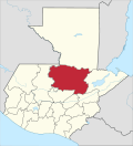
San Pedro Carchá, uisually referred tae as Carchá, is a municipality in the Guatemalan depairtment o Alta Verapaz. It is situatit at 1282 m abuin sea level. It haes an estimatit population 245,000 fowk.[2] It covers a terrain o 1082 km².[3]
Sports
[eedit | eedit soorce]Deportivo Carchá fitbaa club play thair hame gemmes in the Estadio Juan Ramon Ponce Guay. Thay hae played in Guatemala's tap diveesion frae 1998-2001.
References
[eedit | eedit soorce]- ↑ "XI Censo Nacional de Poblacion y VI de Habitación (Censo 2002)". INE. 2002. Archived frae the original on 20 October 2008. Retrieved 7 December 2012.
- ↑ "San Pedro Carchá". inforpressca.com. Retrieved 1 October 2009.
- ↑ "San Pedro Carchá - Ubicación". inforpressca.com. Retrieved 1 October 2009.


