Saba
Appearance
Saba | |
|---|---|
| Motto(s): | |
| Anthem: "Saba you rise frae the ocean" | |
 | |
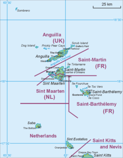
 Cairt shawin location o Saba relative tae Sint Eustatius an Saunt Martin. | |
| Coordinates: 17°38′N 63°15′W / 17.633°N 63.250°W | |
| Kintra | Netherlands |
| Incorporatit intae the Netherlands | 10 October 2010 (dissolution o the Netherlands Antilles) |
| Capital (and largest city) | The Bottom |
| Govrenment | |
| • Lt. Govrenor | Jonathan Johnson |
| Area | |
| • Total | 13 km2 (5 sq mi) |
| Population (2013[1]) | |
| • Total | 1,991 |
| • Density | 150/km2 (400/sq mi) |
| Leids | |
| • Offeecial | Dutch |
| • Recognised regional | Inglis[2] |
| Time zone | UTC−4 (AST) |
| Calling code | +599-4 |
| ISO 3166 code | BQ-SA, NL-BQ2 |
| Siller | U.S. dollar (USD) |
| Internet TLD | .an,[3] .nl |
Saba is a Caribbean isle an the smawest municipality o the Netherlands.
References
[eedit | eedit soorce]- ↑ "Population of Dutch Caribbean (1 January); sex, age: Saba". Statistics Netherlands. 8 Januar 2013. Retrieved 1 August 2013.
- ↑ English can be used in relations with the government
"Invoeringswet openbare lichamen Bonaire, Sint Eustatius en Saba" (in Dutch). wetten.nl. Retrieved 14 October 2012. - ↑ The domain for the Netherlands Antilles haes remained active efter its dissolution. The ISO 3166-1 alpha-2 code BQ wis established for the entity "Bonaire, Sint Eustatius, Saba". ("ISO 3166-1 decoding table". International Organization for Standardization. Archived frae the original on 25 December 2018. Retrieved 17 December 2010.) An Internet ccTLD haes houever nae been established bi the IANA, an it is unkent if it will be opened for registration.
Coordinates: 17°38′N 63°14′W / 17.633°N 63.233°W
| This Europe-relatit airticle is a stub. Ye can help Wikipaedia bi expandin it. |


