
Saarbrücken
Saarbrücken | |
|---|---|
 Saarbrücken in Januar 2006 | |
 Coat airms | |
 Saarbrücken | |
Location o Saarbrücken athin Saarbrücken destrict  | |
| Coordinates: 49°14′N 7°0′E / 49.233°N 7.000°ECoordinates: 49°14′N 7°0′E / 49.233°N 7.000°E | |
| Kintra | Germany |
| State | Saarland |
| Destrict | Saarbrücken |
| Govrenment | |
| • Mayor | Charlotte Britz (SPD) |
| Area | |
| • Total | 167.07 km2 (64.51 sq mi) |
| Population (2021-12-31)[1] | |
| • Total | 179,634 |
| • Density | 1,100/km2 (2,800/sq mi) |
| Time zone | CET/CEST (UTC+1/+2) |
| Postal codes | 66001–66133 |
| Diallin codes | 0681, 06893, 06897, 06898, 06805 |
| Vehicle registration | SB |
Saarbrücken (German pronunciation: [zaːɐ̯ˈbʁʏkən]; French: Sarrebruck, IPA: [saʁbʁyk]) is the caipital o the state o Saarland in Germany. The ceety sits at the hert o a metropolitan aurie that boonds wastwards tae Dillingen an northeastwards tae Neunkirchen, in which maist o the fowk o the Saarland live.
Saarbrücken uised tae be the industrial an transport centre o a great coal basin. Production includit iron an steel, succar, beer, pottery, optical instruments, machinery, an construction materials. Housomeivver, ower the past decades the industrial importance o Saarland haes declined, as the minin industry haes become unprofitable.
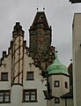
Historic landmarks in the ceety include the stane bridge athort the Saar (1546), the Gothic kirk o St Arnual, the 18t century Saarbrücker Schloss (castle) an the auld pairt o the toun, the St. Johanner Markt. In 1815 Saarbrücken came unner Prussian control, and for twa periods in the 20t century (1919–35 an 1945–57) it became pairt o the Saar territory unner French administration. For this reason, coupled wi its proximity tae the French border, it retains a certain French influence.
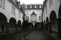
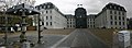
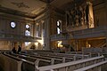
Galery[eedit | eedit soorce]
- Saarbrücken
-
-
-

-

-
-

-
-

-

-


References[eedit | eedit soorce]
- ↑ "Amtliche Einwohnerzahlen Stand 31. Dezember 2021" (PDF) (in German). Statistisches Amt des Saarlandes. Juin 2022.
| Wikimedia Commons haes media relatit tae Saarbrücken. |