Loch Neagh


Loch Neagh is a mukkil freshwattir loch in the middil o Northren Ireland. Its name cums frae the Erse Loch nEathach meinin "loch o Eathach".[1]
Geografie
[eedit | eedit soorce]Wi an aurie o 392 square kilometre (151 sq mi), it is the mukkilest loch in Northren Ireland, the mukkilest loch in Ireland an the mukkilest loch in the Breetish Isles.[2][3] It ranks amang the fortie mukkilest lochs o Europe. Liggin twentie mile (30 km) wast o Belfast, it is aboot twentie mile (30 km) lang an nyn mile (15 km) braid. It is gey shallae aroond the lip an the average deipth in the main bodie is aboot 9 metre (30 ft); awtho at its deipest the loch is aboot 25 metre (80 ft) deip. Its wattir vollum is 3,528 km³.
O the 4550 km² catchment aurie, aboot 9% ligs in the Republic o Ireland an 91% in Northren Ireland;[4] awthegither 43% o the land aurie o Northren Ireland tuims intil the loch.[5] The main river flowin intil an oot o the loch is the River Bann. The Upper Bann flowes intil the loch's soothren end an the Nether Bann flowes oot the northren end toward the sie. The ither main inflowes is the Saxmilewattir, the Glenavy, the Crumlin, the Blekwattir, the Moyola, the Ballinderry an the Main.[6]
Thar's thrie wee-er lochs aroond the lip o Loch Neagh. Thir ar the mukkiler Loch Beg til the north, the wee-er Loch Beg til the aest, an Loch Gullion til the sooth.
Ilands
[eedit | eedit soorce]Thar's a nummer o ilands in the loch, awtho nane is gey lairge. Thir include:
- Coney Iland
- Coney Iland Flat
- Croaghan Flat
- Derrywarragh Iland (the mukkilest)
- Padian
- Ram's Iland
- Phil Roe's Flat
- The Shallae Flat
Touns an veilages
[eedit | eedit soorce]Gaun clockweys frae the northren tip, the main touns an veilages naur the loch ar Toom, Randalstoun, Antrim, Crumlin, Glenavy, Lurgan, Craigavon, Maghery, Ardboe, Derrycrin an Magherafelt. Belfast Internaition Airport ligs naur the aest coast anaw.
Admeinistration
[eedit | eedit soorce]

Coonties
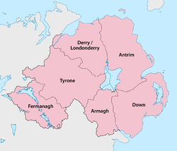
[eedit | eedit soorce]Five o the sax coonties o Northren Ireland hae shores on the loch (anerlie Fermanagh disna). The coonties ar leet'd clockweys:
- Coonty Antrim (aestren hauf o the loch)
- Coonty Doun (a wee bit in the soothaest)
- Coonty Armagh (sooth)
- Coonty Tyrone (wast)
- Coonty Lunnonderry (ferr nor'wast)
Destricts
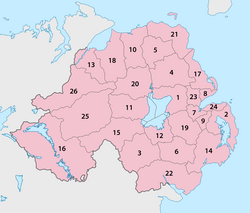
[eedit | eedit soorce]The aurie o the loch is shed atwein sax o Northren Ireland's destricts, whilk ar leet'd clockweys (match the nummers til the cairt on the richt):[7]
- 1 Antrim, in the nor'aest, wi the mukkilest deil
- 19 Lisburn, in the aest, wi the wee-est deil
- 12 Craivagon, in the south
- 15 Dungannon an Sooth Tyrone, in the soothwast
- 11 Cookstoun, in the wast
- 20 Magherafelt, in the nor'wast
Fowklair
[eedit | eedit soorce]An auld Irish fowk tale tells hou the loch wis made whan an etin (sumtyms sayd ti be Fionn mac Cumhaill) scuipit up a collop o the yird an cuist it at a ryval on Gret Breetain. Houaniver, he misst an the collop o yird laundit in the Erse Sie, becumin the Isle o Man.
Referenses
[eedit | eedit soorce]- ↑ Deirdre Flanagan and Laurance Flanagan, Irish Placenames, (Gill & Macmillan Ltd, 1994)
- ↑ "Official Tourism Ireland wabsteid". Archived frae the original on 18 Julie 2011. Retrieved 16 November 2011.
- ↑ Britannica.com
- ↑ "Environmental Change Network". Archived frae the original on 27 September 2007. Retrieved 16 November 2011.
- ↑ "Northern Ireland Rivers Agency". Archived frae the original on 16 Februar 2009. Retrieved 16 November 2011.
- ↑ "Habitas.org". Archived frae the original on 6 Mairch 2012. Retrieved 16 November 2011.
- ↑ Ninis.nisra.gov.uk
Coordinates: 54°37′06″N 6°23′43″W / 54.618333333333°N 6.3952777777778°W
| This Northren Ireland-relatit airticle is a stub. Ye can help Wikipaedia bi expandin it. |
