Katwijk
Appearance
Katwijk | |
|---|---|
 View ower Katwijk aan Zee | |
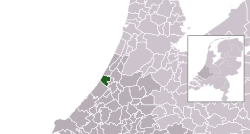
 Location in Sooth Holland | |
| Coordinates: 52°12′N 4°25′E / 52.200°N 4.417°ECoordinates: 52°12′N 4°25′E / 52.200°N 4.417°E | |
| Kintra | Netherlands |
| Province | Sooth Holland |
| Govrenment | |
| • Bodi | Municipal cooncil |
| • Mayor | Cornelis Visser (CDA) |
| Area | |
| • Total | 31.13 km2 (12.02 sq mi) |
| • Laund | 24.54 km2 (9.47 sq mi) |
| • Water | 6.59 km2 (2.54 sq mi) |
| Elevation | 5 m (16 ft) |
| Population (March 2015)[4] | |
| • Total | 63.978 |
| • Density | 2689/km2 (6,960/sq mi) |
| Demonym(s) | Katwijker |
| Time zone | UTC+1 (CET) |
| • Summer (DST) | UTC+2 (CEST) |
| Postcode | 2220–2239 |
| Aurie code | 071 |
| Website | www |
Katwijk (![]() pronunciation (help·info)) is a coastal municipality an toun in the province o Sooth Holland.
pronunciation (help·info)) is a coastal municipality an toun in the province o Sooth Holland.
Sister ceeties
[eedit | eedit soorce] Ohrid, Republic o Macedonie
 Lowestoft, UK (till the 1990s)
 Siegen, Germany (syne merge wi Valkenburg an Rijnsburg) [5]
References
[eedit | eedit soorce]- ↑ "Samenstelling" (in Dutch). Gemeente Katwijk. Archived frae the original on 29 Apryle 2016. Retrieved 31 Julie 2013. Unknown parameter
|trans_title=ignored (help) - ↑ "Kerncijfers wijken en buurten" [Key figures for neighbourhoods]. CBS Statline (in Dutch). CBS. 2 Julie 2013. Retrieved 12 Mairch 2014.
- ↑ "Postcodetool for 2224EW". Actueel Hoogtebestand Nederland (in Dutch). Het Waterschapshuis. Archived frae the original on 25 December 2018. Retrieved 31 Julie 2013. Cite has empty unkent parameter:
|trans_title=(help) - ↑ "Bevolkingsontwikkeling; regio per maand" [Population growth; regions per month]. CBS Statline (in Dutch). CBS. 1 Januar 2021. Retrieved 2 Januar 2022.
- ↑ "Archived copy". Archived frae the original on 24 Julie 2011. Retrieved 6 October 2015.CS1 maint: archived copy as title (link)

