Hispaniola
Appearance
| La Española (Spaingie) Ispayola (Haitian Creole) | |
|---|---|
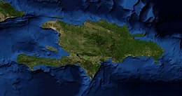
 Satellite eemage, 2008 | |
 | |
| Geografie | |
| Location | Caribbean |
| Coordinates | 19°N 71°W / 19°N 71°W |
| Airchipelagae | Greater Antilles |
| Aurie | 76,480 km2 (29,530 sq mi) |
| Aurie rank | 22nd |
| Coastline | 3,059 km (1,900.8 mi) |
| Heichest elevation | 3,175 m (10,417 ft)[1] |
| Heichest point | Pico Duarte |
| Admeenistration | |
| Demografics | |
| Population | 18,943,000[2] (2005) |
| Pop. density | 241.5 /km2 (625.5 /sq mi) |
Hispaniola (Spaingie: La Española; Haitian Creole: Ispayola; Taíno: Ayiti[3]) is a major Caribbean island comprisin the twa sovereign naitions o Haiti an the Dominican Republic. The island is locatit atween Cuba tae the wast an Puerto Rico tae the east.
Hispaniola is the steid o the first European colonies foondit bi Christopher Columbus on his voyages in 1492 an 1493. It is the tent-maist-populous island in the warld, an the maist populous in the Americas. It is the seicont lairgest island in the Caribbean (efter Cuba) an the 22nt-lairgest island in the warld.
References
[eedit | eedit soorce]- ↑ "Highest Elevation, CIA World Factbook". Archived frae the original on 23 November 2018. Retrieved 18 August 2013.
- ↑ "United Nations World Population Prospects (2008 edition)". Archived frae the original on 19 August 2010. Retrieved 18 August 2013.
- ↑ Jon Henley (14 Januar 2010). "Haiti: a long descent to hell". The Guardian.
