Casperia
Casperia | |
|---|---|
| Comune di Casperia | |
| Coordinates: 42°20′N 12°40′E / 42.333°N 12.667°ECoordinates: 42°20′N 12°40′E / 42.333°N 12.667°E | |
| Kintra | Italy |
| Region | Lazio |
| Province | Province o Rieti (RI) |
| Frazioni | Santa Maria in Legarano, San Vito di Casperia, Paranzano |
| Area | |
| • Total | 25.4 km2 (9.8 sq mi) |
| Elevation | 397 m (1,302 ft) |
| Population (Dec. 2004) | |
| • Total | 1,164 |
| • Density | 46/km2 (120/sq mi) |
| Demonym(s) | Casperiani o aspresi |
| Time zone | UTC+1 (CET) |
| • Summer (DST) | UTC+2 (CEST) |
| Postal code | 02041 |
| Diallin code | 0765 |
| Website | Offeecial wabsteid |
Casperia is a comune (municipality) in the Province o Rieti in the Italian region Lazio, locatit aboot 50 kilometre (31 mi) northeast o Roum an aboot 20 kilometre (12 mi) soothwast o Rieti. As o 31 Dizember 2004, it haed a population o 1,164 an a aurie o 25.4 square kilometre (9.8 sq mi).[1]
The municipality o Casperia conteens the frazioni (subdiveesions, mainly veelages an hamlets) Santa Maria in Legarano, San Vito di Casperia, an Paranzano.
Casperia borders the follaein municipalities: Cantalupo in Sabina, Contigliano, Montasola, Rieti, Roccantica, Torri in Sabina.
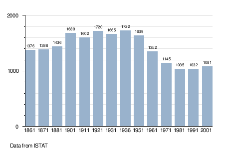
Demographic evolution[eedit | eedit soorce]

References[eedit | eedit soorce]
Freemit airtins[eedit | eedit soorce]
- www.comunedicasperia.it
- www.prolococasperia.it Archived 2018-08-13 at the Wayback Machine

