Baie-James
Municipality of Baie-James | |
|---|---|
| Municipalité de Baie-James | |
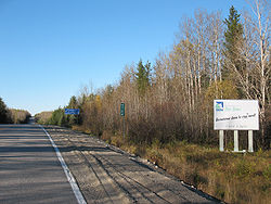
 Walcome sign alang Route 109. | |
 Municipality of Baie-James, Québec. | |
| Coordinates: 52°00′N 74°45′W / 52.000°N 74.750°W | |
| Kintra | |
| Province | |
| Region | Nord-du-Québec |
| RCM/TE | Nane |
| Constitutit | 14 Julie 1971 |
| Dissolvit | 24 Julie 2012 |
| Govrenment | |
| • Mayor | Gérald Lemoyne |
| Area | |
| • Total | 333255.55 km2 (128,670.69 sq mi) |
| • Laund | 297329.66 km2 (114,799.62 sq mi) |
| Population (2006)[2] | |
| • Total | 1,394 |
| • Density | 0.003/km2 (0.008/sq mi) |
| • Chynge (2001-06) | |
| • Dwellins | 870 |
| Time zone | UTC-5 (EST) |
| • Summer (DST) | UTC-4 (EDT) |
| Postal Code | |
| Area code(s) | 819 |
| Website | www.municipalite.baie-james.qc.ca |
The Municipality o Baie-James (French: Municipalité de Baie-James) wis a municipality in northren Quebec, Canadae, which existit frae 1971 tae 2012. Locatit tae the east o James Bay, Baie-James covered 297,332.84 square kilometres o land, an wis the lairgest incorporatit municipality in Canadae — anerly aicht unorganisit territories wur lairger.[3] Its territory amaist entirely (aboot 98%) covered the admeenistrative region o Jamésie, awtho it contained less nor five percent o the population. Essentially, it wis the remainder o the Jamésie Territory's laund efter aw o the major population centres wur remuivit.
On 24 Julie 2012, the Quebec govrenment signed an accord wi the Cree that wad result in the abolition o Baie-James an the creation o a regional govrenment kent as Eeyou Istchee James Bay Territory.[4]
The hydroelectric pouer plants o the La Grande Complex wur aw locatit athin the municipal bundaries o Baie-James, makkin the municipality strategically important tae Quebec's energy policy. Ither important economic sectors are minin, softwood loggin, forestry, an tourism.
History
[eedit | eedit soorce]The municipality wis creatit in 1971 an wis run bi the buird o directors o the Société de développement de la Baie James. It manages the territory o the James Bay an Northren Quebec Greement atween the 49t an 55t parallel, wi the exception o the Cree Category 1 lands an the enclaves o Chapais, Chibougamau, Lebel-sur-Quévillon an Matagami.
In Dizember 2001, the municipal cooncil wis reformit. It became a municipality o a special teep directit bi the mayors o the fower enclave touns, as well as the chairpersons o the local community cooncils o Radisson, Valcanton an Villebois. An aicht seat is reservit for a representative comin frae the nan-urban territory. The municipality gained additional authority an can exert certaint pouers as a regional coonty.
Unner the terms o the Agreement on Governance in the Eeyou Istchee James Bay Territory o 24 Julie 2012, the municipality ceased tae exist an wis replacit bi a new regional govrenment cried Eeyou Istchee James Bay Territory.[5]
Commonties in Baie-James
[eedit | eedit soorce]- Beaucanton
- Desmaraisville
- Joutel
- Miquelon
- Radisson - northren-maist nan-native toun in Quebec.
- Val-Paradis
- Valcanton
- Villebois
Demographics
[eedit | eedit soorce]Population:[6]
- Population in 2006: 1394
- Population in 2001: 1422
- 2001 tae 2006 population chynge: -2.0 %
- Population in 1996: 1978
- Population in 1991: 3073
Tot private dwellins, excludin saisonal cottages: 606 (tot: 870)
Transportation
[eedit | eedit soorce]The primary roads tae an athin Baie-James wur:
- Route 109 - provincial heich-gate tae Matagami
- Route 113 - provincial heich-gate frae Val-d'Or tae Chibougamau
- Route 393 - regional heich-gate tae Val-Paradis
- James Bay Road - road frae Matagami tae Radisson
- North Road
- Trans-Taiga Road - access road tae hydro-electric stations o the James Bay Project
Air transportation is throu the La Grande Rivière Airport naur Radisson, which provides scheduled air service tae Montreal an Puvirnituq.
Geografie
[eedit | eedit soorce]Nearby lochs include Lake Naococane.
References
[eedit | eedit soorce]- ↑ a b Ministère des Affaires Municipales et Régions: Baie-James
- ↑ a b 2006 Statistics Canada Community Profile: Baie-James, Quebec
- ↑ Population and dwelling counts, for Canada, provinces and territories, and census subdivisions (municipalities), 2006 and 2001 censuses[deid airtin]
- ↑ Lia Lévesque (24 Julie 2012). "Québec et les Cris signent une entente pour un gouvernement régional". La Presse. La Presse Canadienne. Retrieved 24 Julie 2012.
- ↑ http://www.gcc.ca/newsarticle.php?id=280 Archived 2014-11-13 at the Wayback Machine
- ↑ Statistics Canada: 1996, 2001, 2006 census
Freemit airtins
[eedit | eedit soorce]- Municipality o Baie-James Archived 2011-03-08 at the Wayback Machine
- Human Environment o the James Bay region Archived 2006-05-06 at the Wayback Machine (Detailed map o the James Bay region)
- Map o Baie-James Archived 2011-09-26 at the Wayback Machine
