Atyrau Region
Atyrau Oblast Атырау облысы Атырауская область | |
|---|---|
 | |
| Coordinates: 47°07′0″N 51°53′0″E / 47.11667°N 51.88333°E | |
| Kintra | Kazakhstan |
| Caipital | Atyrau |
| Govrenment | |
| • Akim (govrenor) | Bergey Ryskaliev |
| Area | |
| • Total | 118600 km2 (45,800 sq mi) |
| Population (2006)[1] | |
| • Total | 479,984 |
| • Density | 4.0/km2 (10/sq mi) |
| Time zone | UTC+5 |
| Area code(s) | +7 (712) |
| ISO 3166-2 | ATY |
| Licence plate | E |
| Destricts | 7 |
| Ceeties (inc touns) | 2 |
| Tounships | 10 |
| Veelages | 188 |
| Website | e-atyrau.kz |
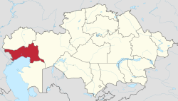
Atyrau Oblast (Kazakh: [Атырау облысы, Atıraw oblısı] error: {{lang}}: text has italic markup (help)) is a province o Kazakhstan. It is situatit in the wast o the kintra aroond the northeast o the Caspian Sea. Its caipital is the ceety o Atyrau, wi a population o 142,500 fowk; the province itsel haes 480,000 fowk. Kazakhs mak up mair nor 80% o population.
Geography
[eedit | eedit soorce]Wi an aurie o 118,600 square kilometers, it is the seicont-smawest province in Kazakhstan (Sooth Kazakhstan Province is the smawest). It borders the neighborin kintra Roushie tae the west, as well as the fellae Kazakh provinces Aktobe (tae the east), Mangystau (tae the sooth), an the Wast Kazakhstan Province (tae the north).
A lairge pairt o the province is situatit in the ile-rich Caspian Depression; acause o this, mony ile wells hae been drilled in the Tengiz Field an Kashagan Field auries. An pipeline runs frae Atyrau tae Samara, where it joins the Roushie pipeline seestem. A separate ile pipeline runs frae the Tengiz field tae the Roushie Black Sea port o Novorossiisk.
Atyrau is traversed bi the northeasterly line o equal latitude an langitude.
Freemit airtins
[eedit | eedit soorce]- Offeecial wabsteid Archived 2011-12-28 at the Wayback Machine
References
[eedit | eedit soorce]- National Geographic Atlas of the World, Eighth Edition.


