
Alushta
Alushta Алушта Aluşta | |
|---|---|
 | |
 Banner  Coat airms | |
 Alushta Location o Alushta within Crimea | |
| Coordinates: 44°40′2″N 34°23′52″E / 44.66722°N 34.39778°ECoordinates: 44°40′2″N 34°23′52″E / 44.66722°N 34.39778°E | |
| Kintra | Disputed: |
| Republic | |
| Region | Alushta municipality |
| Area | |
| • Total | 6.983 km2 (2.696 sq mi) |
| Elevation | 50 m (160 ft) |
| Population | |
| • Total | 28,418 |
| • Density | 4264.78/km2 (11,045.7/sq mi) |
| Time zone | UTC+3 (MSK) |
| Postal code | 98500 — 98519 |
| Area code(s) | +380-6560 |
| Umwhile name | Aluston (til the 15t century) |
| Website | http://www.alushta.crimea.ua/ |
Alushta (Ukrainian an Roushie: Алу́шта; Crimean Tatar: Aluşta; Greek: Alouston) is a ceety o regional signeeficance on the soothren coast o the Autonomous Republic o Crimea in Ukraine claimed bi Roushie as the Republic o Crimea.
Internaitional relations
[eedit | eedit soorce]Twin touns — Sister ceeties
[eedit | eedit soorce]Alushta is twinned wi:
-
 Lusta fortress, XIV
 -
-
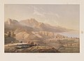
 Alushta 1869
 -

-
-

.jpg)


.JPG)

References
[eedit | eedit soorce]- ↑ "Sadraudzības pilsētas". jurmala.lv. Archived frae the original on 4 Mairch 2016. Retrieved 26 Apryle 2014. (in Latvie) (in Inglis)