Zaozyorsk
Appearance
Zaozyorsk Заозёрск | |
|---|---|
 Overview of Zaozyorsk | |
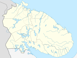
| Coordinates: 69°24′N 32°37′E / 69.400°N 32.617°ECoordinates: 69°24′N 32°37′E / 69.400°N 32.617°E | |
| Kintra | Roushie |
| Federal subject | Murmansk Oblast[1] |
| Foondit | 1958 |
| Govrenment | |
| • Mayor | Pyotr Bogdanovich |
| Area | |
| • Total | 118 km2 (46 sq mi) |
| Elevation | 60 m (200 ft) |
| Population | |
| • Total | 11,199 |
| • Density | 95/km2 (250/sq mi) |
| • Subordinatit tae | closed admeenistrative-territorial formation o Zaozyorsk[1] |
| • Caipital o | closed admeenistrative-territorial formation o Zaozyorsk[1] |
| • Urban okrug | Zaozyorsk Urban Okrug[3] |
| • Caipital o | Zaozyorsk Urban Okrug[3] |
| Time zone | UTC+3 (Moscow Time |
| Postal code(s)[5] | 184310 |
| Dialin code(s) | +7 81556 |
| OKTMO ID | 47733000001 |
| Website | www |

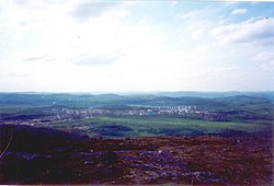
Zaozyorsk (Roushie: Заозёрск), umwhile cried Murmansk-150 (Му́рманск-150),[citation needit] is a closed toun in Murmansk Oblast, Roushie. Population: 11,199 (2010 Census);[2] 12,687 (2002 Census).[6]
History
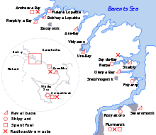
[eedit | eedit soorce]Zaozyorsk wis oreeginally formit in 1958 tae serve as a base for a nuclear unnerwatter fleet that wis tae pertect Soviet northren sea border. The base wis renamit Zapadnaya Litsa in 1959.
Admeenistrative an municipal status
[eedit | eedit soorce]Admeenistratively, it is incorporatit as the closed admeenistrative-territorial formation o Zaozyorsk—an admeenistrative unit wi the status equal tae that o the destricts.[1] Municipally, the closed admeenistrative-territorial formation o Zaozyorsk is incorporatit as Zaozyorsk Urban Okrug.[3]
References
[eedit | eedit soorce]Notes
[eedit | eedit soorce]- ↑ a b c d e Law #96-01-ZMO
- ↑ a b Roushie Federal State Stateestics Service (2011). "Всероссийская перепись населения 2010 года. Том 1" [2010 Aw-Roushie Population Census, vol. 1]. Всероссийская перепись населения 2010 года [2010 Aw-Roushie Population Census] (in Roushie). Federal State Stateestics Service.CS1 maint: ref=harv (link) CS1 maint: unrecognised leid (link)
- ↑ a b c Law #530-01-ZMO
- ↑ "Об исчислении времени". Официальный интернет-портал правовой информации (in Roushie). 3 Juin 2011. Retrieved 19 Januar 2019.CS1 maint: unrecognised leid (link)
- ↑ Local post office http://www.russianpost.ru/PostOfficeFindInterface/FindOPSByPostOfficeID.aspx?index=184310
- ↑ Roushie Federal State Stateestics Service (21 Mey 2004). "Численность населения России, субъектов Российской Федерации в составе федеральных округов, районов, городских поселений, сельских населённых пунктов – районных центров и сельских населённых пунктов с населением 3 тысячи и более человек" [Population o Roushie, Its Federal Destricts, Federal Subjects, Destricts, Urban Localities, Rural Localities—Admeenistrative Centres, an Rural Localities wi Population o Ower 3,000] (XLS). Всероссийская перепись населения 2002 года [Aw-Roushie Population Census o 2002] (in Roushie).CS1 maint: ref=harv (link) CS1 maint: unrecognised leid (link)
Sources
[eedit | eedit soorce]- Мурманская областная Дума. Закон №96-01-ЗМО от 6 января 1998 г. «Об административно-территориальном устройстве Мурманской области», в ред. Закона №1577-01-ЗМО от 1 марта 2013 г. «О порядке рассмотрения предложений о присвоении наименований географическим объектам и переименовании географических объектов». Опубликован: "Мурманский Вестник", №10, стр. 3, 16 января 1998 г. (Murmansk Oblast Duma. Law #96-01-ZMO of January 6, 1998 On the Administrative-Territorial Structure of Murmansk Oblast, as amended by the Law #1577-01-ZMO of March 1, 2013 On the Procedures of Examination of the Suggested Names of Geographical Entities and of Renaming the Geographical Entities. ).
- Template:RussiaAdmMunRef/mur/munlist/zaozyorsk


