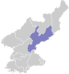
Yonggwang
Yonggwang | |
|---|---|
| Korean transcription(s) | |
| • Hangul | 영광군 |
| • Hanja | 榮光郡 |
| • Revised Romanisation | Yeonggwang-gun |
| • McCune–Reischauer | Yŏnggwang kun |
| Kintra | North Korea |
| Admeenistrative diveesions | 1 ŭp, 1 wirkers' destrict, 24 ri |
Yonggwang is a coonty in Hamgyongnam-do, North Korea. It wis oreeginally pairt o Hamju Coonty, frae which it wis separatit in a general reorganisation o local govrenment in 1952. It is the steid o ane o the steles erectit bi Jinheung in the 6t century.
The coonty is primarily muntainous, an is traversed bi the Pujonryong Muntains (부전령산맥). Housomeivver, thare are auries o rollin an level grund, especially alang the Songchon River (성천강). Ither significant streams include the Hukrim River (흑림강), Chadongchon (자동천), Chonbulsanchon (천불산천), an Kigokchon (기곡천). Roughly 80% o the coonty is occupee'd bi forestland. The heichest point is Mataesan.
Despite the ruggit terrain, thare is agricultur in Yonggwang. Local crops include maize, rice, soybeans, wheat, an barley. Sma-scale orchards an livestock operations exist an aw. Thare are deposits o coal an gowd. In addition, hydroelectric pouer is producit in the region.
The Sinhŭng Line an Changjin Line railroads pass through the coonty, which is servit bi roads an aw.

