
Villa de Tututepec de Melchor Ocampo
Villa de Tututepec de Melchor Ocampo | |
|---|---|
Municipality an toun | |
 Villa de Tututepec de Melchor Ocampo Location in Mexico | |
| Coordinates: 16°08′N 97°36′W / 16.133°N 97.600°WCoordinates: 16°08′N 97°36′W / 16.133°N 97.600°W | |
| Kintra | |
| State | Oaxaca |
| Area | |
| • Total | 1,249 km2 (482 sq mi) |
| Elevation | 280 m (920 ft) |
| Time zone | UTC-6 (Central Staundart Time) |
| • Summer (DST) | UTC-5 (Central Daylicht Time) |

Villa de Tututepec de Melchor Ocampo is a toun an municipality in Oaxaca in sooth-wastren Mexico.
History
[eedit | eedit soorce]Afore the arrival o Spainyie, the aurie wis occupee'd bi a smaw Mixtec kinrick, established in 357 AD,[1] when Prince Mazatzin arrivit frae Tilantongo. Upon climbin a muntain full o seabirds, Prince Mazatzin decidit tae foond his caipital in this bonnie location, cawin it “Yucu – Saa”, or "Bird muntain" in the Mixtec leid.
Tututepec servit as a Mixtec caipital unner Aicht Deer Jaguar Claw, maintainin its unthirldom despite comin unner attack frae the Aztecs atween 1483-1519.
When the conquistador Pedro de Alvarado arrivit on 3 Mairch 1522, he defeatit Tututepec's warriors, who focht unner Cuaxintecutli (Venerable Laird Serpent). Cuaxintecutli dee'd frae tortur on 22 Mairch 1522. In Apryle 1522, Hernán Cortés muivit the Villa de la Segura de la Frontera tae Tututepec, an instawed Gutierre de Badajoz as the first mayor.[2]
Geografie
[eedit | eedit soorce]Tututepec is pairt o the Juquila Destrict in the centre o the Costa Region. The name "Tututepec" means "Bird Muntain".[1]
The municipality covers a aurie o 1,249 km² at a average altitude o 280 m abuin sea level, leein on the Paceefic coast o Oaxaca. The climate is het an humid. Flora include palmera, cotton, coffee, citrus, melons, bananaes, lemon, hibiscus. Fauna include iguanas, deer, snakes an lochs wi abundant fish. The municipality includes the lairge Lagunas de Chacahua Naitional Pairk an the airchaeological steid o Villa Segura Tututepec.[1]
Demographics
[eedit | eedit soorce]As o 2005, the municipality haed 9,397 hoosehaulds wi a tot population o 40,767 o which 2,144 spoke a indigenous leid, Tututepec Mixtec.[1][3] 90% o the population is engagit in cultivation o fruits sic as wattermelon, cantaloupe, papaya, hibiscus, an banana. Mony o the fowk engage in smaw-scale ainimal husbandry an aw, an some mak pots, jars, beads an blouses.[1]
Cultur
[eedit | eedit soorce]Champurrado, a tradeetional chocolate-based atole drink, is considered a seembol o Mixtec cultur. It wis servit at a ceremony commemoratin the 1656t anniversar o the municipality, wi a blessin o fuid, thanks tae mither yird, an a tradeetional mass o thanksgivin. A caravan o bicyclists an ither guests o honour inauguratit the openin o a exposition o airtisan handicrafts an local cuisine, alang wi a beuk fair.[4]
Gallery
[eedit | eedit soorce]-
 Stilt hoose on Chacahua lagoon
 -
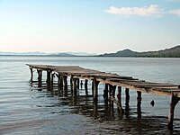 Pier in Cacahua lagoon
 -
 Surfer in Cacahua lagoon


See an aw
[eedit | eedit soorce]- Tututepec, airchaeological steid
References
[eedit | eedit soorce]- ↑ a b c d e "-". Enciclopedia de los Municipios de México. Instituto Nacional para el Federalismo y el Desarrollo Municipal. Archived frae the original on 28 Mey 2007. Retrieved 12 Juin 2009.
- ↑ "Historia de Tututepec". H. Ayuntamiento Constitucional de Villa de Tututepec, Juq., Oax. 2013. Archived frae the original on 27 Julie 2013. Retrieved 19 September 2013.
- ↑ Tututepec Mixtec at Ethnologue (17th ed., 2013)
- ↑ ""TUTUTEPEC" Simplemente el más antiguo de la costa oaxaqueña". H. Ayuntamiento Constitucional de Villa de Tututepec, Juq., Oax. Retrieved 19 September 2013.[deid airtin]
Freemit airtins
[eedit | eedit soorce]- Tututepec offeecial wabsteid Archived 2014-12-18 at the Wayback Machine, (in Spainyie)