Taehung
Taehung | |
|---|---|
| Korean transcription(s) | |
| • Hangul | 대흥군 |
| • Hanja | 大興郡 |
| • Revised Romanisation | Taeheung-gun |
| • McCune–Reischauer | Taehŭng kun |
| Kintra | North Korea |
| Admeenistrative diveesions | 1 ŭp, 1 wirkers' destrict, 16 ri |
| Area | |
| • Total | 1224 km2 (473 sq mi) |
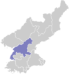
Taehung is a kun, or coonty, in the northeastren corner o Pyongannam-do, North Korea. It is bordered tae the north bi Yongrim an Changjin, tae the east bi Yonggwang an Hamju, tae the sooth bi Yodok an Chongpyong, an tae the wast bi Yongwon an Tongsin. It is drained bi the Taedong River, which rises in the north pairt o the coonty afore flowin wast intae Yongwon.
The terrain o Taehung is heicher an mair muntainous than ony ither pairt o Pyongannam-do. Three muntain ranges, the Rangrim, Myohyang, an Puktaebong, pass through the coonty. The heichest o the mony peaks is Tongdaesan, at 2,094 meters abuin sea level.
Local agricultur is dominatit bi dry-field fermin, wi maize the chief crop. Lumber is sent doun the Taedong River for processin. Thare are subterranean reserves o tungsten, gowd, copper, an zinc. Thare are nae railroads, but the coonty is servit bi roads which connect it tae neebourin touns via the muntain passes.
See an aw
[eedit | eedit soorce]Freemit airtins
[eedit | eedit soorce]- (in Korean) In Korean leid online encyclopaedias:

