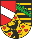
Saale-Holzland-Kreis
Saale-Holzland | |
|---|---|
 | |
| Kintra | |
| State | Thuringie |
| Caipital | Eisenberg |
| Area | |
| • Total | 817 km2 (315 sq mi) |
| Population (31 December 2021)[1] | |
| • Total | 82,513 |
| • Density | 100/km2 (260/sq mi) |
| Time zone | UTC+1 (CET) |
| • Summer (DST) | UTC+2 (CEST) |
| Vehicle registration | SHK, EIS, SRO |
| Website | www.saale-holzland-kreis.de |
Saale-Holzland (offeecial German name Saale-Holzland-Kreis) is a Kreis (destrict) in the east o Thuringie, Germany. Neebourin destricts are (frae the north clockwise) the destrict Burgenlandkreis in Saxony-Anhalt, the destrict-free ceety Gera, the destricts Greiz, Saale-Orla-Kreis, Saalfeld-Rudolstadt, Weimarer Land an the destrict-free ceety Jena.
History[eedit | eedit soorce]
The destrict wis creatit in 1994 bi mergin the previous destricts Eisenberg, Jena an Stadtroda. When the district Roda (later Stadtroda) wis oreeginally creatit in 1922 it awready covered nearly the aurie o the current destrict. In 1952 thegither wi the abolishment o the federal states (Bundesländer) the destrict wis split intae the three pairts, which wur put thegither again in 1994.
Geografie[eedit | eedit soorce]
The main river in the destrict is the Saale, which gave it its name an aw. The heichest elevation wi 475 m abuin sea level is in the sooth o the destrict, the lawest wi 118 m is in the Saale valley at the boondar tae the destrict Weimarer Land.
Coat o airms[eedit | eedit soorce]

|
In the left o the coat o airms is the siller bar as the seembol o the Lairds o Lobdeburg, who awned o the valley of the Saale in the 13t century. In the bottom is the lion o the Coonts o Orlamünde, surroondit bi 6 herts. Their coonty went intae the awnership o the Wettin faimily in 1396. The coat o airms o Saxony in the richt is the same as the coat o airms o the Wettin, as they later became the rulers o Saxony. The coat o airms wis appruivit on 18 August 1997. |
Touns an municipalities[eedit | eedit soorce]
| Verwaltungsgemeinschaft-free touns | an municipalities | |
|---|---|---|
| Verwaltungsgemeinschaften | ||
|---|---|---|
|
3. Hermsdorf |
5. Südliches Saaletal | |
| 1seat o the Verwaltungsgemeinschaft;2town | ||
References[eedit | eedit soorce]
Freemit airtins[eedit | eedit soorce]
- Offeecial wabsteid (German)
