
Sëlva
Sëlva | |
|---|---|
| Chemun de Sëlva Comune di Selva dVG Gemeinde Wolkenstein in Gröden | |
 | |
 Sëlva Location o Sëlva in Italy | |
| Coordinates: 46°33′N 11°46′E / 46.550°N 11.767°ECoordinates: 46°33′N 11°46′E / 46.550°N 11.767°E | |
| Kintra | Italy |
| Region | Trentino-Alto Adige/Südtirol |
| Province | Sooth Tyrol (BZ) |
| Frazioni | Plan |
| Govrenment | |
| • Mayor | Peter Mussner (SVP) |
| Area | |
| • Total | 53.2 km2 (20.5 sq mi) |
| Elevation | 1563 m (5,128 ft) |
| Population (Nov. 2010) | |
| • Total | 2,637 |
| • Density | 50/km2 (130/sq mi) |
| Demonym(s) | German: Wolkensteiner Italian: gardenesi |
| Time zone | UTC+1 (CET) |
| • Summer (DST) | UTC+2 (CEST) |
| Postal code | 39048 |
| Diallin code | 0471 |
| Website | Offeecial wabsteid |
Sëlva (![]() pronunciation (help·info), German: Wolkenstein in Gröden; Italian: Selva di Val Gardena) is a comune (municipality) in the Val Gardena in Sooth Tyrol, northren Italy, locatit aboot 30 kilometre (19 mi) east o the ceety o Bolzano. The Ladin place name derives frae the Laitin silva ("firth").
pronunciation (help·info), German: Wolkenstein in Gröden; Italian: Selva di Val Gardena) is a comune (municipality) in the Val Gardena in Sooth Tyrol, northren Italy, locatit aboot 30 kilometre (19 mi) east o the ceety o Bolzano. The Ladin place name derives frae the Laitin silva ("firth").
Geografie
[eedit | eedit soorce]As o 30 Dizember 2010, it haed a population o 2,637 an a aurie o 53.2 square kilometre (20.5 sq mi).[1] Sëlva borders the follaein municipalities: Badia, Campitello di Fassa, Canazei, Corvara, San Martin de Tor, an Santa Cristina Gherdëina.
It is aiblins best kent as ane o the stairtin points o the Sella Ronda ski tour.
History
[eedit | eedit soorce]Coat-o-airms
[eedit | eedit soorce]The emblem is quairterly, the first an third corners are per bend an per fess nebuly o argent an gules; the seicont an third corners are indentit o azur an argent on a sable tap. The emblem represents the insignia o the Lairds o Wolkenstein who built the local castle in 1291. The emblem wis adoptit in 1968.[2]
Society
[eedit | eedit soorce]Linguistic distribution
[eedit | eedit soorce]Accordin tae the 2011 census, 89.74% o the population speak Ladin, 5.11% Italian an 5.15% German as first leid.[3]
Demographic evolution
[eedit | eedit soorce]
-
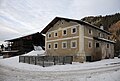 The fermhoose Piciulëi in Sëlva Gherdëina. Soothren aspect

References
[eedit | eedit soorce]- ↑ Aw demographics an ither statistics: Italian statistical institute Istat.
- ↑ "Heraldry of the World: Sëlva". Archived frae the original on 1 August 2012. Retrieved 2 December 2014.
- ↑ "Volkszählung 2011/Censimento della popolazione 2011". astat info. Provincial Statistics Institute of the Autonomous Province of South Tyrol (38): 6–7. Juin 2012. Retrieved 14 Juin 2012.
Freemit airtins
[eedit | eedit soorce]![]() Media relatit tae Sëlva at Wikimedia Commons
Media relatit tae Sëlva at Wikimedia Commons
- (in Italian) (in German) Hamepage o the municipality
