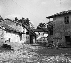
Poljane pri Podgradu
Appearance
Poljane pri Podgradu | |
|---|---|
Veelage | |
 Poljane in 1955 | |
| Coordinates: 45°30′20.48″N 14°5′51.51″E / 45.5056889°N 14.0976417°ECoordinates: 45°30′20.48″N 14°5′51.51″E / 45.5056889°N 14.0976417°E | |
| Kintra | |
| Region | Slovenie Littoral |
| Municipality | Hrpelje–Kozina |
| Area | |
| • Total | 9.17 km2 (3.54 sq mi) |
| Elevation | 416.8 m (1,367.5 ft) |
| Population (2002) | |
| • Total | 9 |
| [1] | |
Poljane pri Podgradu (pronounced [pɔˈljaːnɛ pɾi pɔdˈgɾaːdu]; Italian: Pogliane) is a smaw veelage in the Municipality o Hrpelje–Kozina in the Littoral region o Slovenie close tae the border wi Croatie.[2]
Name
[eedit | eedit soorce]The name o the dounset wis chyngit frae Poljane tae Poljane pri Podgradu in 1953.[3]
Kirk
[eedit | eedit soorce]The local kirk is dedicatit tae Saunt Anthony o Padua an belangs tae the Pairish o Golac.[4]
References
[eedit | eedit soorce]- ↑ Statistical Office of the Republic of Slovenia
- ↑ Hrpelje–Kozina municipal site Archived 2008-12-18 at the Wayback Machine
- ↑ Spremembe naselij 1948–95. 1996. Database. Ljubljana: Geografski inštitut ZRC SAZU, DZS.
- ↑ Roman Catholic Diocese of Koper List of Churches May 2008
Freemit airtins
[eedit | eedit soorce]| Wikimedia Commons haes media relatit tae Poljane pri Podgradu. |
- Poljane pri Podgradu on Geopedia Archived 2017-07-29 at the Wayback Machine

