Perama
Perama Πέραμα | |
|---|---|
| Coordinates: 37°58′N 23°34′E / 37.967°N 23.567°ECoordinates: 37°58′N 23°34′E / 37.967°N 23.567°E | |
| Kintra | Greece |
| Admeenistrative region | Attica |
| Regional unit | Piraeus |
| Govrenment | |
| • Mayor | Pantelis Zoumboulis (Ind.) |
| Area | |
| • Municipality | 14.73 km2 (5.69 sq mi) |
| Elevation | 5 m (16 ft) |
| Population (2011)[1] | |
| • Municipality | 25389 |
| • Municipality density | 1,700/km2 (4,500/sq mi) |
| Time zone | UTC+2 (EET) |
| • Summer (DST) | UTC+3 (EEST) |
| Postal code | 188 63 |
| Aurie code(s) | 210 |
| Vehicle registration | Z |
| Website | www.perama.gr |
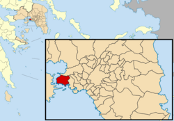
Perama (Greek: Πέραμα) is a port ceety an a suburb o Piraeus, Greece that lees on the soothwast edge o the Aegaleo muntains. It creates the wastren terminus o the Port o Piraeus (Athens' port) an thare is a port that provides ferry services tae Salamis an aw. The toun haes anerly ane main road connectin Lambrakis an Ralli Avenues, alang wi the rest o Athens. Hintle o the commonty is rocky an muntainous.
Perama haes schuils, lyceums, gymnasia, banks, a polis station a post office, a seicontar soccer team namit Peramaikos F.C. an squares (plateies).
Historical population[eedit | eedit soorce]
| Year | Municipality |
|---|---|
| 1981 | 23,012 |
| 1991 | 24,119 |
| 2001 | 25,720 |
| 2011 | 25,389 |
See an aw[eedit | eedit soorce]
References[eedit | eedit soorce]
- ↑ a b "Απογραφή Πληθυσμού - Κατοικιών 2011. ΜΟΝΙΜΟΣ Πληθυσμός" (in Greek). Hellenic Statistical Authority.
Freemit airtins[eedit | eedit soorce]
- Offeecial wabsteid (in Greek)


